Ipís geodata
Ipís (San José) is a populated place; located in Costa Rica in America/Costa_Rica (GMT-6) time zone. With population of 26,669 people, there are 18 cities with bigger population in this country. Compared to other cities in Costa Rica, 50% of cities are located further ↓South; 72.4% of cities are located further ←West and 92.5% of cities have lower elevation than Ipís. Note1


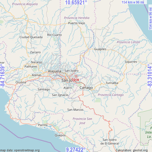
Ipís GPS coordinates[2]
9° 58' 2.82" North, 84° 0' 47.736" West
| Map corner | latitude | longitude |
|---|---|---|
| Upper-left | 10.65921°, | -84.71639° |
| Center: | 9.96745°, | -84.01326° |
| Lower-right: | 9.27422°, | -83.31014° |
| Map W x H: | 154×154 km | = 95.7×95.7mi |
| max Lat: | 11.07377° ⇑50% North |
| Ipís: | 9.96745° |
| min Lat: | ⇓50% South 8.53305° |
| min Long | Ipís | max Long |
| -85.64748° | -84.01326° | -82.62185° |
| W 72.4%⇐ | ⇒27.6% E |
Elevation
Elevation of Ipís is 1352 m = 4436 ft, and this is 617 m = 2024 ft above average elevation for this country.
| Max E: |
1844 m = 6050 ft | 7.5% |
| Ipís | 1352 m 4436 ft | |
| Avg. | 735 m = 2411 ft | |
Min E: |
7 m = 23 ft | 92.5% |
See also: Costa Rica elevation on elevation.city.
Geographical zone
Ipís is located in North Torrid zone (between Equator and Tropic of Cancer). Distance of Equator is 1108.3 km =688.7 mi to South.| Distance of | km | miles | from Ipís |
|---|---|---|---|
| North Pole | 8898.8 | 5529.5 | to North |
| Arctic Circle | 6292.9 | 3910.2 | to North |
| Tropic Cancer | 1497.6 | 930.6 | to North |
| Equator | 1108.3 | 688.7 | to South |


Nearby cities:
15 places around Ipís: (largest is in red/bold)
• Calle Blancos
6.2 km =3.9 mi,  251°
251°
• Colima
8.1 km =5 mi,  256°
256°
• Concepción
4.1 km =2.5 mi,  159°
159°
• Curridabat
6.6 km =4.1 mi,  200°
200°
• Granadilla
3.6 km =2.2 mi,  186°
186°
• Guadalupe
5.2 km =3.2 mi, 245°
• Purral
2.2 km =1.4 mi,  241°
241°
• Sabanilla
3.8 km =2.4 mi,  229°
229°
• San Diego
7.7 km =4.8 mi,  171°
171°
• San Juan
7.5 km =4.7 mi, 263°
• San Pedro
6 km =3.7 mi,  223°
223°
• San Vicente
3.8 km =2.4 mi, 257°
• San Vicente de Moravia
3.9 km =2.4 mi, 260°
• Tres Ríos
7.3 km =4.5 mi, 157°
• Ángeles
5.2 km =3.2 mi,  307°
307°
Sources, notices
• [Note1] Compared only with cities in Costa Rica existing in our database
• [Src1] Map data: © OpenStreetMap contributors (CC-BY-SA)
• [Src2] Other city data from geonames.org with taken over terms of usage.
• [Src3] Geographical zone / Annual Mean Temperature by Robert A. Rohde @ Wikipedia
