Concepción geodata
Concepción (Cartago) is a populated place; located in Costa Rica in America/Costa_Rica (GMT-6) time zone. With population of 14,000 people, there are 42 cities with bigger population in this country. Compared to other cities in Costa Rica, 59% of cities are located further ↑North; 73.9% of cities are located further ←West and 93.3% of cities have lower elevation than Concepción. Note1


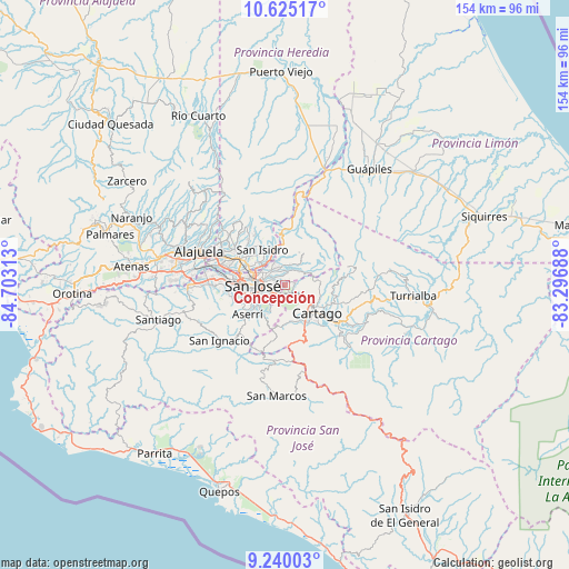
Concepción GPS coordinates[2]
9° 55' 59.988" North, 84° 0' 0" West
| Map corner | latitude | longitude |
|---|---|---|
| Upper-left | 10.62517°, | -84.70313° |
| Center: | 9.93333°, | -84° |
| Lower-right: | 9.24003°, | -83.29688° |
| Map W x H: | 154×154 km | = 95.7×95.7mi |
| max Lat: | 11.07377° ⇑59% North |
| Concepción: | 9.93333° |
| min Lat: | ⇓41% South 8.53305° |
| min Long | Concepción | max Long |
| -85.64748° | -84° | -82.62185° |
| W 73.9%⇐ | ⇒26.1% E |
Elevation
Elevation of Concepción is 1388 m = 4554 ft, and this is 653 m = 2142 ft above average elevation for this country.
| Max E: |
1844 m = 6050 ft | 6.7% |
| Concepción | 1388 m 4554 ft | |
| Avg. | 735 m = 2411 ft | |
Min E: |
7 m = 23 ft | 93.3% |
See also: Costa Rica elevation on elevation.city.
Geographical zone
Concepción is located in North Torrid zone (between Equator and Tropic of Cancer). Distance of Equator is 1104.5 km =686.3 mi to South.| Distance of | km | miles | from Concepción |
|---|---|---|---|
| North Pole | 8902.6 | 5531.8 | to North |
| Arctic Circle | 6296.7 | 3912.6 | to North |
| Tropic Cancer | 1501.4 | 932.9 | to North |
| Equator | 1104.5 | 686.3 | to South |


Nearby cities:
15 places around Concepción: (largest is in red/bold)
• Calle Blancos
7.5 km =4.7 mi,  284°
284°
• Curridabat
4.4 km =2.7 mi,  237°
237°
• Granadilla
1.9 km =1.2 mi, 275°
• Guadalupe
6.4 km =4 mi, 284°
• Ipís
4.1 km =2.5 mi,  339°
339°
• Patarrá
7 km =4.3 mi,  213°
213°
• Purral
4.3 km =2.7 mi,  309°
309°
• Sabanilla
4.5 km =2.8 mi,  287°
287°
• San Diego
3.8 km =2.4 mi,  184°
184°
• San José
9.1 km =5.7 mi,  270°
270°
• San Pedro
5.6 km =3.5 mi,  264°
264°
• San Vicente
6 km =3.7 mi,  299°
299°
• San Vicente de Moravia
6.2 km =3.9 mi, 300°
• Tres Ríos
3.3 km =2.1 mi,  155°
155°
• Ángeles
8.9 km =5.5 mi,  321°
321°
Sources, notices
• [Note1] Compared only with cities in Costa Rica existing in our database
• [Src1] Map data: © OpenStreetMap contributors (CC-BY-SA)
• [Src2] Other city data from geonames.org with taken over terms of usage.
• [Src3] Geographical zone / Annual Mean Temperature by Robert A. Rohde @ Wikipedia
