Calle Blancos geodata
Calle Blancos (San José) is a populated place; located in Costa Rica in America/Costa_Rica (GMT-6) time zone. With population of 20,710 people, there are 31 cities with bigger population in this country. Compared to other cities in Costa Rica, 54.5% of cities are located further ↑North; 61.2% of cities are located further ←West and 74.6% of cities have lower elevation than Calle Blancos. Note1


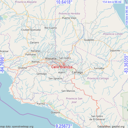
Calle Blancos GPS coordinates[2]
9° 57' 0" North, 84° 4' 0.012" West
| Map corner | latitude | longitude |
|---|---|---|
| Upper-left | 10.6418°, | -84.7698° |
| Center: | 9.95°, | -84.06667° |
| Lower-right: | 9.25673°, | -83.36355° |
| Map W x H: | 154×154 km | = 95.7×95.7mi |
| max Lat: | 11.07377° ⇑54.5% North |
| Calle Blancos: | 9.95° |
| min Lat: | ⇓45.5% South 8.53305° |
| min Long | Calle Blancos | max Long |
| -85.64748° | -84.06667° | -82.62185° |
| W 61.2%⇐ | ⇒38.8% E |
Elevation
Elevation of Calle Blancos is 1188 m = 3898 ft, and this is 453 m = 1486 ft above average elevation for this country.
| Max E: |
1844 m = 6050 ft | 25.4% |
| Calle Blancos | 1188 m 3898 ft | |
| Avg. | 735 m = 2411 ft | |
Min E: |
7 m = 23 ft | 74.6% |
See also: Costa Rica elevation on elevation.city.
Geographical zone
Calle Blancos is located in North Torrid zone (between Equator and Tropic of Cancer). Distance of Equator is 1106.3 km =687.4 mi to South.| Distance of | km | miles | from Calle Blancos |
|---|---|---|---|
| North Pole | 8900.7 | 5530.6 | to North |
| Arctic Circle | 6294.8 | 3911.4 | to North |
| Tropic Cancer | 1499.6 | 931.8 | to North |
| Equator | 1106.3 | 687.4 | to South |


Nearby cities:
15 places around Calle Blancos: (largest is in red/bold)
• Alajuelita
6.5 km =4 mi,  214°
214°
• Colima
2 km =1.2 mi,  272°
272°
• Curridabat
5.5 km =3.4 mi,  139°
139°
• Granadilla
5.7 km =3.5 mi,  107°
107°
• Guadalupe
1.1 km =0.7 mi,  101°
101°
• Ipís
6.2 km =3.9 mi,  71°
71°
• Purral
4.1 km =2.5 mi,  77°
77°
• Sabanilla
3 km =1.9 mi, 100°
• San José
2.6 km =1.6 mi,  224°
224°
• San Juan
2 km =1.2 mi,  303°
303°
• San Pablo
6 km =3.7 mi,  327°
327°
• San Pedro
3 km =1.9 mi, 144°
• San Vicente
2.4 km =1.5 mi,  61°
61°
• San Vicente de Moravia
2.3 km =1.4 mi, 56°
• Ángeles
5.4 km =3.4 mi,  18°
18°
Sources, notices
• [Note1] Compared only with cities in Costa Rica existing in our database
• [Src1] Map data: © OpenStreetMap contributors (CC-BY-SA)
• [Src2] Other city data from geonames.org with taken over terms of usage.
• [Src3] Geographical zone / Annual Mean Temperature by Robert A. Rohde @ Wikipedia
