Alajuelita geodata
Alajuelita (San José) is a populated place; located in Costa Rica in America/Costa_Rica (GMT-6) time zone. With population of 13,845 people, there are 43 cities with bigger population in this country. Compared to other cities in Costa Rica, 68.7% of cities are located further ↑North; 53% of cities are located further ←West and 70.1% of cities have lower elevation than Alajuelita. Note1


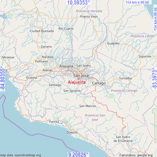
Alajuelita GPS coordinates[2]
9° 54' 5.868" North, 84° 6' 1.512" West
| Map corner | latitude | longitude |
|---|---|---|
| Upper-left | 10.59353°, | -84.80355° |
| Center: | 9.90163°, | -84.10042° |
| Lower-right: | 9.20826°, | -83.3973° |
| Map W x H: | 154×154 km | = 95.7×95.7mi |
| max Lat: | 11.07377° ⇑68.7% North |
| Alajuelita: | 9.90163° |
| min Lat: | ⇓31.3% South 8.53305° |
| min Long | Alajuelita | max Long |
| -85.64748° | -84.10042° | -82.62185° |
| W 53%⇐ | ⇒47% E |
Elevation
Elevation of Alajuelita is 1135 m = 3724 ft, and this is 400 m = 1312 ft above average elevation for this country.
| Max E: |
1844 m = 6050 ft | 29.9% |
| Alajuelita | 1135 m 3724 ft | |
| Avg. | 735 m = 2411 ft | |
Min E: |
7 m = 23 ft | 70.1% |
See also: Costa Rica elevation on elevation.city.
Geographical zone
Alajuelita is located in North Torrid zone (between Equator and Tropic of Cancer). Distance of Equator is 1101 km =684.1 mi to South.| Distance of | km | miles | from Alajuelita |
|---|---|---|---|
| North Pole | 8906.1 | 5534 | to North |
| Arctic Circle | 6300.2 | 3914.8 | to North |
| Tropic Cancer | 1505 | 935.2 | to North |
| Equator | 1101 | 684.1 | to South |


Nearby cities:
15 places around Alajuelita: (largest is in red/bold)
• Aserrí
4.8 km =3 mi,  169°
169°
• Calle Blancos
6.5 km =4 mi,  34°
34°
• Colima
5.7 km =3.5 mi,  17°
17°
• Curridabat
7.4 km =4.6 mi,  81°
81°
• Escazú
4.7 km =2.9 mi,  293°
293°
• Guadalupe
7 km =4.3 mi,  42°
42°
• Salitrillos
5.6 km =3.5 mi, 168°
• San Felipe
0.7 km =0.4 mi,  302°
302°
• San José
4 km =2.5 mi, 27°
• San Juan
6.8 km =4.2 mi, 17°
• San Juan de Dios
3.2 km =2 mi,  147°
147°
• San Miguel
5.5 km =3.4 mi,  127°
127°
• San Pedro
6.2 km =3.9 mi,  61°
61°
• San Rafael
5 km =3.1 mi,  305°
305°
• San Rafael Arriba
3.9 km =2.4 mi,  138°
138°
Sources, notices
• [Note1] Compared only with cities in Costa Rica existing in our database
• [Src1] Map data: © OpenStreetMap contributors (CC-BY-SA)
• [Src2] Other city data from geonames.org with taken over terms of usage.
• [Src3] Geographical zone / Annual Mean Temperature by Robert A. Rohde @ Wikipedia
