Manzanillo geodata
Manzanillo (Granma) is a seat of a second-order administrative division; located in Cuba in America/Havana (GMT-4) time zone. With population of 128,188 people, there are 19 cities with bigger population in this country. Compared to other cities in Cuba, 90.1% of cities are located further ↑North; 77.3% of cities are located further ←West and 63% of cities have higher elevation than Manzanillo. Note1


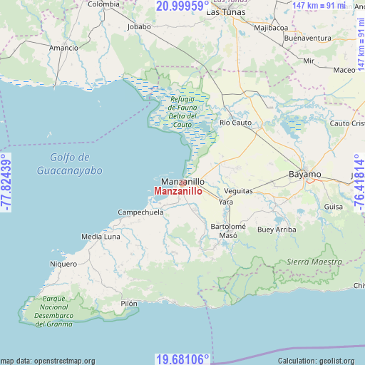
Manzanillo GPS coordinates[2]
20° 20' 30.228" North, 77° 7' 16.536" West
| Map corner | latitude | longitude |
|---|---|---|
| Upper-left | 20.99959°, | -77.82439° |
| Center: | 20.34173°, | -77.12126° |
| Lower-right: | 19.68106°, | -76.41814° |
| Map W x H: | 146.6×146.6 km | = 91.1×91.1mi |
| max Lat: | 23.15917° ⇑90.1% North |
| Manzanillo: | 20.34173° |
| min Lat: | ⇓9.9% South 19.90553° |
| min Long | Manzanillo | max Long |
| -84.28599° | -77.12126° | -74.15181° |
| W 77.3%⇐ | ⇒22.7% E |
Elevation
Elevation of Manzanillo is 32 m = 105 ft, and this is 36.6 m = 120 ft below average elevation for this country.
| Max E: |
761 m = 2497 ft | 63% |
| Avg. | 68.6 m = 225 ft | |
| Manzanillo | 32 m = 105 ft | |
Min E: |
3 m = 10 ft | 37% |
See also: Manzanillo elevation on elevation.city.
Geographical zone
Manzanillo is located in North Torrid zone (between Equator and Tropic of Cancer). Distance of this Northern Tropic circle is 344.1 km =213.8 mi to North.| Distance of | km | miles | from Manzanillo |
|---|---|---|---|
| North Pole | 7745.3 | 4812.7 | to North |
| Arctic Circle | 5139.4 | 3193.5 | to North |
| Tropic Cancer | 344.1 | 213.8 | to North |
| Equator | 2261.8 | 1405.4 | to South |


Nearby cities:
15 places around Manzanillo: (largest is in red/bold)
• Amancio
71.4 km =44.4 mi,  318°
318°
• Bartolomé Masó
27 km =16.8 mi,  136°
136°
• Bayamo
49.9 km =31 mi,  85°
85°
• Buey Arriba
42.5 km =26.4 mi,  116°
116°
• Calixto
69.4 km =43.1 mi,  22°
22°
• Campechuela
20.5 km =12.7 mi,  233°
233°
• Cauto Cristo
71.7 km =44.6 mi,  70°
70°
• Guisa
61.5 km =38.2 mi,  99°
99°
• Jobabo
65.1 km =40.5 mi,  345°
345°
• Las Tunas
71.2 km =44.2 mi,  14°
14°
• Media Luna
39.5 km =24.5 mi,  236°
236°
• Niquero
58.1 km =36.1 mi, 235°
• Pilón
52.8 km =32.8 mi,  203°
203°
• Río Cauto
32.3 km =20.1 mi,  41°
41°
• Yara
19.2 km =11.9 mi,  112°
112°
Sources, notices
• [Note1] Compared only with cities in Cuba existing in our database
• [Src1] Map data: © OpenStreetMap contributors (CC-BY-SA)
• [Src2] Other city data from geonames.org with taken over terms of usage.
• [Src3] Geographical zone / Annual Mean Temperature by Robert A. Rohde @ Wikipedia
