Bayamo geodata
Bayamo (Granma) is a seat of a first-order administrative division; located in Cuba in America/Havana (GMT-4) time zone. With population of 192,632 people, there are 9 cities with bigger population in this country. Compared to other cities in Cuba, 87.3% of cities are located further ↑North; 81.8% of cities are located further ←West and 55.2% of cities have lower elevation than Bayamo. Note1


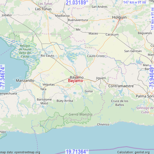
Bayamo GPS coordinates[2]
20° 22' 27.012" North, 76° 38' 36.996" West
| Map corner | latitude | longitude |
|---|---|---|
| Upper-left | 21.03189°, | -77.34674° |
| Center: | 20.37417°, | -76.64361° |
| Lower-right: | 19.71364°, | -75.94049° |
| Map W x H: | 146.6×146.6 km | = 91.1×91.1mi |
| max Lat: | 23.15917° ⇑87.3% North |
| Bayamo: | 20.37417° |
| min Lat: | ⇓12.7% South 19.90553° |
| min Long | Bayamo | max Long |
| -84.28599° | -76.64361° | -74.15181° |
| W 81.8%⇐ | ⇒18.2% E |
Elevation
Elevation of Bayamo is 58 m = 190 ft, and this is 10.6 m = 35 ft below average elevation for this country.
| Max E: |
761 m = 2497 ft | 44.8% |
| Avg. | 68.6 m = 225 ft | |
| Bayamo | 58 m = 190 ft | |
Min E: |
3 m = 10 ft | 55.2% |
See also: Bayamo elevation on elevation.city.
Geographical zone
Bayamo is located in North Torrid zone (between Equator and Tropic of Cancer). Distance of this Northern Tropic circle is 340.5 km =211.6 mi to North.| Distance of | km | miles | from Bayamo |
|---|---|---|---|
| North Pole | 7741.7 | 4810.5 | to North |
| Arctic Circle | 5135.8 | 3191.2 | to North |
| Tropic Cancer | 340.5 | 211.6 | to North |
| Equator | 2265.4 | 1407.7 | to South |


Nearby cities:
15 places around Bayamo: (largest is in red/bold)
• Bartolomé Masó
38.8 km =24.1 mi,  233°
233°
• Buey Arriba
25.4 km =15.8 mi,  207°
207°
• Cacocum
52.2 km =32.4 mi,  39°
39°
• Calixto
65.2 km =40.5 mi,  338°
338°
• Campechuela
68.2 km =42.4 mi,  256°
256°
• Cauto Cristo
27 km =16.8 mi, 41°
• Contramaestre
42.4 km =26.3 mi,  101°
101°
• Guisa
17.1 km =10.6 mi,  140°
140°
• Holguín
69.4 km =43.1 mi,  34°
34°
• Jiguaní
22.5 km =14 mi,  91°
91°
• Manzanillo
49.9 km =31 mi,  265°
265°
• Palma Soriano
70.2 km =43.6 mi, 104°
• Río Cauto
35.1 km =21.8 mi,  305°
305°
• San Germán
58.8 km =36.5 mi,  64°
64°
• Yara
33.9 km =21.1 mi,  250°
250°
Sources, notices
• [Note1] Compared only with cities in Cuba existing in our database
• [Src1] Map data: © OpenStreetMap contributors (CC-BY-SA)
• [Src2] Other city data from geonames.org with taken over terms of usage.
• [Src3] Geographical zone / Annual Mean Temperature by Robert A. Rohde @ Wikipedia
