Las Tunas geodata
Las Tunas is a seat of a first-order administrative division; located in Cuba in America/Havana (GMT-4) time zone. With population of 203,684 people, there are 8 cities with bigger population in this country. Compared to other cities in Cuba, 76.8% of cities are located further ↑North; 78.5% of cities are located further ←West and 76.2% of cities have lower elevation than Las Tunas. Note1


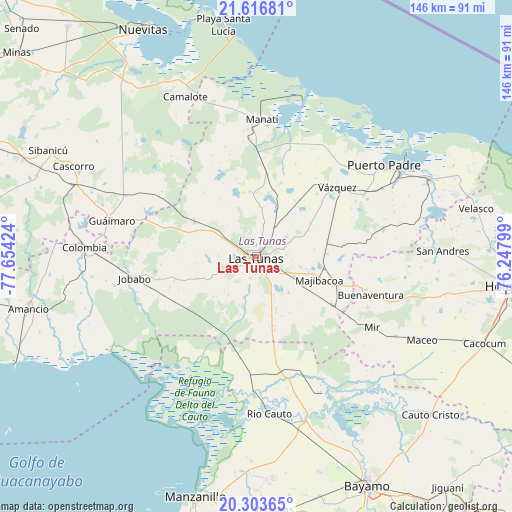
Las Tunas GPS coordinates[2]
20° 57' 42.012" North, 76° 57' 3.996" West
| Map corner | latitude | longitude |
|---|---|---|
| Upper-left | 21.61681°, | -77.65424° |
| Center: | 20.96167°, | -76.95111° |
| Lower-right: | 20.30365°, | -76.24799° |
| Map W x H: | 146×146 km | = 90.7×90.7mi |
| max Lat: | 23.15917° ⇑76.8% North |
| Las Tunas: | 20.96167° |
| min Lat: | ⇓23.2% South 19.90553° |
| min Long | Las Tunas | max Long |
| -84.28599° | -76.95111° | -74.15181° |
| W 78.5%⇐ | ⇒21.5% E |
Elevation
Elevation of Las Tunas is 91 m = 299 ft, and this is 22.4 m = 73 ft above average elevation for this country.
| Max E: |
761 m = 2497 ft | 23.8% |
| Las Tunas | 91 m 299 ft | |
| Avg. | 68.6 m = 225 ft | |
Min E: |
3 m = 10 ft | 76.2% |
See also: Las Tunas elevation on elevation.city.
Geographical zone
Las Tunas is located in North Torrid zone (between Equator and Tropic of Cancer). Distance of this Northern Tropic circle is 275.2 km =171 mi to North.| Distance of | km | miles | from Las Tunas |
|---|---|---|---|
| North Pole | 7676.3 | 4769.8 | to North |
| Arctic Circle | 5070.5 | 3150.7 | to North |
| Tropic Cancer | 275.2 | 171 | to North |
| Equator | 2330.7 | 1448.2 | to South |


Nearby cities:
15 places around Las Tunas: (largest is in red/bold)
• Amancio
67.2 km =41.8 mi,  256°
256°
• Cacocum
69.6 km =43.2 mi,  110°
110°
• Calixto
9.5 km =5.9 mi,  119°
119°
• Cauto Cristo
67.1 km =41.7 mi,  132°
132°
• Colombia
49.4 km =30.7 mi,  273°
273°
• Guáimaro
42.6 km =26.5 mi,  283°
283°
• Holguín
71.9 km =44.7 mi,  96°
96°
• Jesús Menéndez
53.8 km =33.4 mi,  65°
65°
• Jobabo
34.9 km =21.7 mi, 260°
• Jobabo
67.7 km =42.1 mi,  89°
89°
• Manatí
38.8 km =24.1 mi,  2°
2°
• Manzanillo
71.2 km =44.2 mi,  194°
194°
• Puerto Padre
44.4 km =27.6 mi,  54°
54°
• Río Cauto
44.8 km =27.8 mi,  175°
175°
• Sibanicú
67 km =41.6 mi,  297°
297°
Sources, notices
• [Note1] Compared only with cities in Cuba existing in our database
• [Src1] Map data: © OpenStreetMap contributors (CC-BY-SA)
• [Src2] Other city data from geonames.org with taken over terms of usage.
• [Src3] Geographical zone / Annual Mean Temperature by Robert A. Rohde @ Wikipedia
