Guisa geodata
Guisa (Granma) is a seat of a second-order administrative division; located in Cuba in America/Havana (GMT-4) time zone. With population of 18,408 people, there are 113 cities with bigger population in this country. Compared to other cities in Cuba, 91.7% of cities are located further ↑North; 82.9% of cities are located further ←West and 95.6% of cities have lower elevation than Guisa. Note1


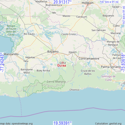
Guisa GPS coordinates[2]
20° 15' 17.784" North, 76° 32' 21.48" West
| Map corner | latitude | longitude |
|---|---|---|
| Upper-left | 20.91317°, | -77.24243° |
| Center: | 20.25494°, | -76.5393° |
| Lower-right: | 19.59391°, | -75.83618° |
| Map W x H: | 146.7×146.7 km | = 91.2×91.2mi |
| max Lat: | 23.15917° ⇑91.7% North |
| Guisa: | 20.25494° |
| min Lat: | ⇓8.3% South 19.90553° |
| min Long | Guisa | max Long |
| -84.28599° | -76.5393° | -74.15181° |
| W 82.9%⇐ | ⇒17.1% E |
Elevation
Elevation of Guisa is 201 m = 659 ft, and this is 132.4 m = 434 ft above average elevation for this country.
| Max E: |
761 m = 2497 ft | 4.4% |
| Guisa | 201 m 659 ft | |
| Avg. | 68.6 m = 225 ft | |
Min E: |
3 m = 10 ft | 95.6% |
See also: Cuba elevation on elevation.city.
Geographical zone
Guisa is located in North Torrid zone (between Equator and Tropic of Cancer). Distance of this Northern Tropic circle is 353.8 km =219.8 mi to North.| Distance of | km | miles | from Guisa |
|---|---|---|---|
| North Pole | 7754.9 | 4818.7 | to North |
| Arctic Circle | 5149 | 3199.4 | to North |
| Tropic Cancer | 353.8 | 219.8 | to North |
| Equator | 2252.1 | 1399.4 | to South |


Nearby cities:
15 places around Guisa: (largest is in red/bold)
• Bartolomé Masó
43.3 km =26.9 mi,  256°
256°
• Bayamo
17.1 km =10.6 mi,  320°
320°
• Buey Arriba
24.5 km =15.2 mi,  247°
247°
• Cacocum
58.1 km =36.1 mi,  22°
22°
• Cauto Cristo
34.3 km =21.3 mi,  11°
11°
• Contramaestre
31.1 km =19.3 mi,  80°
80°
• El Cobre
66.1 km =41.1 mi,  110°
110°
• Holguín
76 km =47.2 mi, 22°
• Jiguaní
17.1 km =10.6 mi,  42°
42°
• Manzanillo
61.5 km =38.2 mi,  279°
279°
• Palma Soriano
57.1 km =35.5 mi,  94°
94°
• Río Cauto
51.9 km =32.2 mi,  310°
310°
• San Germán
57.1 km =35.5 mi,  47°
47°
• San Luis
72.3 km =44.9 mi,  95°
95°
• Yara
43 km =26.7 mi,  272°
272°
Sources, notices
• [Note1] Compared only with cities in Cuba existing in our database
• [Src1] Map data: © OpenStreetMap contributors (CC-BY-SA)
• [Src2] Other city data from geonames.org with taken over terms of usage.
• [Src3] Geographical zone / Annual Mean Temperature by Robert A. Rohde @ Wikipedia
