Jagüey Grande geodata
Jagüey Grande (Matanzas) is a seat of a second-order administrative division; located in Cuba in America/Havana (GMT-4) time zone. With population of 54,363 people, there are 42 cities with bigger population in this country. Compared to other cities in Cuba, 60.8% of cities are located further ↓South; 65.2% of cities are located further →East and 84% of cities have higher elevation than Jagüey Grande. Note1


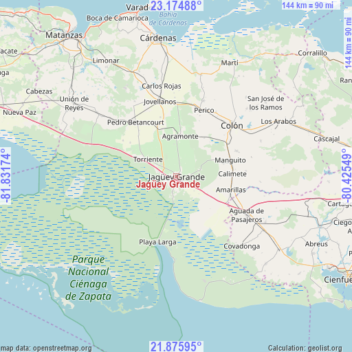
Jagüey Grande GPS coordinates[2]
22° 31' 36.984" North, 81° 7' 42.996" West
| Map corner | latitude | longitude |
|---|---|---|
| Upper-left | 23.17488°, | -81.83174° |
| Center: | 22.52694°, | -81.12861° |
| Lower-right: | 21.87595°, | -80.42549° |
| Map W x H: | 144.4×144.4 km | = 89.7×89.7mi |
| max Lat: | 23.15917° ⇑39.2% North |
| Jagüey Grande: | 22.52694° |
| min Lat: | ⇓60.8% South 19.90553° |
| min Long | Jagüey Grande | max Long |
| -84.28599° | -81.12861° | -74.15181° |
| W 34.8%⇐ | ⇒65.2% E |
Elevation
Elevation of Jagüey Grande is 16 m = 52 ft, and this is 52.6 m = 173 ft below average elevation for this country.
| Max E: |
761 m = 2497 ft | 84% |
| Avg. | 68.6 m = 225 ft | |
| Jagüey Grande | 16 m = 52 ft | |
Min E: |
3 m = 10 ft | 16% |
See also: Jagüey Grande elevation on elevation.city.
Geographical zone
Jagüey Grande is located in North Torrid zone (between Equator and Tropic of Cancer). Distance of this Northern Tropic circle is 101.2 km =62.9 mi to North.| Distance of | km | miles | from Jagüey Grande |
|---|---|---|---|
| North Pole | 7502.3 | 4661.7 | to North |
| Arctic Circle | 4896.4 | 3042.5 | to North |
| Tropic Cancer | 101.2 | 62.9 | to North |
| Equator | 2504.8 | 1556.4 | to South |


Nearby cities:
15 places around Jagüey Grande: (largest is in red/bold)
• Aguada de Pasajeros
32.9 km =20.4 mi,  118°
118°
• Alacranes
52.4 km =32.6 mi,  300°
300°
• Bolondrón
42 km =26.1 mi,  308°
308°
• Calimete
22.4 km =13.9 mi,  87°
87°
• Colón
31.5 km =19.6 mi,  46°
46°
• Cárdenas
57.2 km =35.5 mi,  352°
352°
• Jovellanos
31.4 km =19.5 mi, 348°
• Limonar
55.3 km =34.4 mi,  328°
328°
• Los Arabos
47.5 km =29.5 mi,  61°
61°
• Manguito
23 km =14.3 mi,  73°
73°
• Martí
51.4 km =31.9 mi,  24°
24°
• Pedro Betancourt
27.7 km =17.2 mi,  323°
323°
• Perico
29.3 km =18.2 mi, 22°
• Rodas
62.3 km =38.7 mi,  109°
109°
• Unión de Reyes
51.4 km =31.9 mi, 305°
Sources, notices
• [Note1] Compared only with cities in Cuba existing in our database
• [Src1] Map data: © OpenStreetMap contributors (CC-BY-SA)
• [Src2] Other city data from geonames.org with taken over terms of usage.
• [Src3] Geographical zone / Annual Mean Temperature by Robert A. Rohde @ Wikipedia
