Limonar geodata
Limonar (Matanzas) is a seat of a second-order administrative division; located in Cuba in America/Havana (GMT-4) time zone. With population of 25,421 people, there are 88 cities with bigger population in this country. Compared to other cities in Cuba, 86.2% of cities are located further ↓South; 68% of cities are located further →East and 68.5% of cities have lower elevation than Limonar. Note1


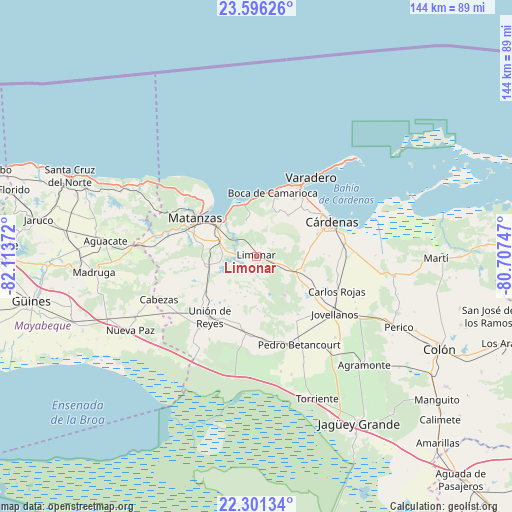
Limonar GPS coordinates[2]
22° 57' 1.26" North, 81° 24' 38.124" West
| Map corner | latitude | longitude |
|---|---|---|
| Upper-left | 23.59626°, | -82.11372° |
| Center: | 22.95035°, | -81.41059° |
| Lower-right: | 22.30134°, | -80.70747° |
| Map W x H: | 144×144 km | = 89.5×89.5mi |
| max Lat: | 23.15917° ⇑13.8% North |
| Limonar: | 22.95035° |
| min Lat: | ⇓86.2% South 19.90553° |
| min Long | Limonar | max Long |
| -84.28599° | -81.41059° | -74.15181° |
| W 32%⇐ | ⇒68% E |
Elevation
Elevation of Limonar is 71 m = 233 ft, and this is 2.4 m = 8 ft above average elevation for this country.
| Max E: |
761 m = 2497 ft | 31.5% |
| Limonar | 71 m 233 ft | |
| Avg. | 68.6 m = 225 ft | |
Min E: |
3 m = 10 ft | 68.5% |
See also: Cuba elevation on elevation.city.
Geographical zone
Limonar is located in North Torrid zone (between Equator and Tropic of Cancer). Distance of this Northern Tropic circle is 54.1 km =33.6 mi to North.| Distance of | km | miles | from Limonar |
|---|---|---|---|
| North Pole | 7455.2 | 4632.4 | to North |
| Arctic Circle | 4849.3 | 3013.2 | to North |
| Tropic Cancer | 54.1 | 33.6 | to North |
| Equator | 2551.8 | 1585.6 | to South |


Nearby cities:
15 places around Limonar: (largest is in red/bold)
• Alacranes
26 km =16.2 mi,  218°
218°
• Bolondrón
21.2 km =13.2 mi,  190°
190°
• Cárdenas
23 km =14.3 mi,  65°
65°
• Jagüey Grande
55.3 km =34.4 mi,  148°
148°
• Jovellanos
27.8 km =17.3 mi,  125°
125°
• Madruga
45.9 km =28.5 mi,  264°
264°
• Martí
50.3 km =31.3 mi,  90°
90°
• Matanzas
19.8 km =12.3 mi,  300°
300°
• Nueva Paz
41.1 km =25.5 mi,  239°
239°
• Pedro Betancourt
27.7 km =17.2 mi, 153°
• Perico
44.9 km =27.9 mi,  116°
116°
• San Nicolás de Bari
54.7 km =34 mi,  250°
250°
• Santa Cruz del Norte
57.4 km =35.7 mi,  293°
293°
• Unión de Reyes
21.5 km =13.4 mi, 216°
• Varadero
28.6 km =17.8 mi,  36°
36°
Sources, notices
• [Note1] Compared only with cities in Cuba existing in our database
• [Src1] Map data: © OpenStreetMap contributors (CC-BY-SA)
• [Src2] Other city data from geonames.org with taken over terms of usage.
• [Src3] Geographical zone / Annual Mean Temperature by Robert A. Rohde @ Wikipedia
