Páno Kivídes geodata
Páno Kivídes (Limassol) is a populated place; located in Cyprus in Asia/Nicosia (GMT+3) time zone. With population of 703 people, there are 97 cities with bigger population in this country. Compared to other cities in Cyprus, 82.9% of cities are located further ↑North; 75.2% of cities are located further →East and 91.5% of cities have lower elevation than Páno Kivídes. Note1


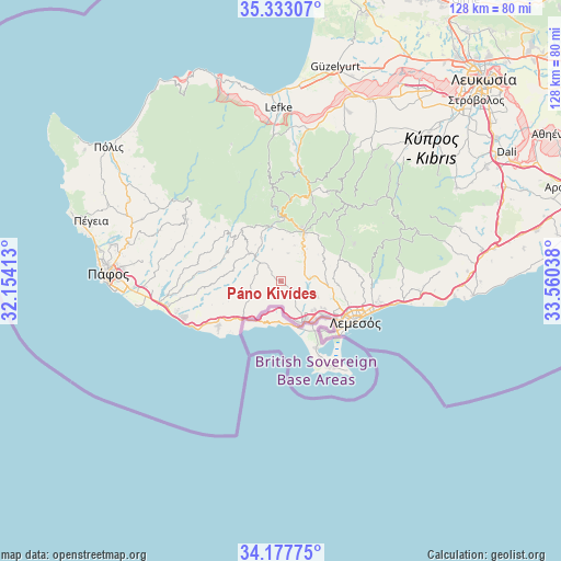
Páno Kivídes GPS coordinates[2]
34° 45' 26.748" North, 32° 51' 26.1" East
| Map corner | latitude | longitude |
|---|---|---|
| Upper-left | 35.33307°, | 32.15413° |
| Center: | 34.75743°, | 32.85725° |
| Lower-right: | 34.17775°, | 33.56038° |
| Map W x H: | 128.5×128.5 km | = 79.8×79.8mi |
| max Lat: | 35.59719° ⇑82.9% North |
| Páno Kivídes: | 34.75743° |
| min Lat: | ⇓17.1% South 34.66865° |
| min Long | Páno Kivídes | max Long |
| 32.38166° | 32.85725° | 34.37916° |
| W 24.8%⇐ | ⇒75.2% E |
Elevation
Elevation of Páno Kivídes is 578 m = 1896 ft, and this is 370 m = 1214 ft above average elevation for this country.
| Max E: |
1134 m = 3720 ft | 8.5% |
| Páno Kivídes | 578 m 1896 ft | |
| Avg. | 208 m = 682 ft | |
Min E: |
4 m = 13 ft | 91.5% |
See also: Cyprus elevation on elevation.city.
Geographical zone
Páno Kivídes is located in North temperate zone (between Tropic of Cancer and the Arctic Circle). Distance of this Northern Tropic circle is 1258.7 km =782.1 mi to South.| Distance of | km | miles | from Páno Kivídes |
|---|---|---|---|
| North Pole | 6142.4 | 3816.7 | to North |
| Arctic Circle | 3536.5 | 2197.5 | to North |
| Tropic Cancer | 1258.7 | 782.1 | to South |
| Equator | 3864.7 | 2401.4 | to South |


Nearby cities:
15 places around Páno Kivídes: (largest is in red/bold)
• Agrós
23.1 km =14.4 mi,  39°
39°
• Avdímou
11.2 km =7 mi,  230°
230°
• Erími
10.5 km =6.5 mi,  147°
147°
• Kakopetriá
26 km =16.2 mi,  9°
9°
• Kolossi
12.1 km =7.5 mi,  144°
144°
• Kyperoúnta
22.8 km =14.2 mi,  28°
28°
• Limassol
18.4 km =11.4 mi,  116°
116°
• Mouttagiáka
22.6 km =14 mi,  100°
100°
• Palodeia
13.6 km =8.5 mi, 95°
• Peléndri
18.4 km =11.4 mi, 33°
• Pissoúri
17.3 km =10.7 mi,  235°
235°
• Páchna
6.3 km =3.9 mi,  292°
292°
• Páno Polemídia
13.7 km =8.5 mi,  114°
114°
• Sotíra
5.1 km =3.2 mi,  173°
173°
• Ýpsonas
12.3 km =7.6 mi,  128°
128°
Sources, notices
• [Note1] Compared only with cities in Cyprus existing in our database
• [Src1] Map data: © OpenStreetMap contributors (CC-BY-SA)
• [Src2] Other city data from geonames.org with taken over terms of usage.
• [Src3] Geographical zone / Annual Mean Temperature by Robert A. Rohde @ Wikipedia
