Sotíra geodata
Sotíra (Limassol) is a populated place; located in Cyprus in Asia/Nicosia (GMT+2) time zone. With population of 4,444 people, there are 25 cities with bigger population in this country. Compared to other cities in Cyprus, 93.2% of cities are located further ↑North; 74.4% of cities are located further →East and 75.2% of cities have lower elevation than Sotíra. Note1


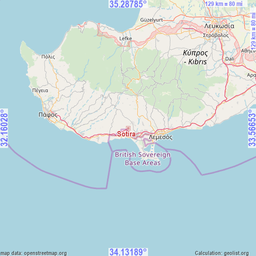
Sotíra GPS coordinates[2]
34° 42' 42.804" North, 32° 51' 48.24" East
| Map corner | latitude | longitude |
|---|---|---|
| Upper-left | 35.28785°, | 32.16028° |
| Center: | 34.71189°, | 32.8634° |
| Lower-right: | 34.13189°, | 33.56653° |
| Map W x H: | 128.5×128.5 km | = 79.8×79.8mi |
| max Lat: | 35.59719° ⇑93.2% North |
| Sotíra: | 34.71189° |
| min Lat: | ⇓6.8% South 34.66865° |
| min Long | Sotíra | max Long |
| 32.38166° | 32.8634° | 34.37916° |
| W 25.6%⇐ | ⇒74.4% E |
Elevation
Elevation of Sotíra is 292 m = 958 ft, and this is 84 m = 276 ft above average elevation for this country.
| Max E: |
1134 m = 3720 ft | 24.8% |
| Sotíra | 292 m 958 ft | |
| Avg. | 208 m = 682 ft | |
Min E: |
4 m = 13 ft | 75.2% |
See also: Cyprus elevation on elevation.city.
Geographical zone
Sotíra is located in North temperate zone (between Tropic of Cancer and the Arctic Circle). Distance of this Northern Tropic circle is 1253.7 km =779 mi to South.| Distance of | km | miles | from Sotíra |
|---|---|---|---|
| North Pole | 6147.5 | 3819.9 | to North |
| Arctic Circle | 3541.6 | 2200.6 | to North |
| Tropic Cancer | 1253.7 | 779 | to South |
| Equator | 3859.6 | 2398.2 | to South |


Nearby cities:
15 places around Sotíra: (largest is in red/bold)
• Agrós
26.9 km =16.7 mi,  31°
31°
• Avdímou
9.4 km =5.8 mi,  257°
257°
• Erími
6.3 km =3.9 mi,  127°
127°
• Kolossi
8 km =5 mi, 126°
• Kouklia
26.5 km =16.5 mi,  269°
269°
• Limassol
16.3 km =10.1 mi,  100°
100°
• Mouttagiáka
21.7 km =13.5 mi,  87°
87°
• Palodeia
13.5 km =8.4 mi,  74°
74°
• Peléndri
22.6 km =14 mi, 25°
• Pissoúri
15.6 km =9.7 mi,  252°
252°
• Páchna
9.8 km =6.1 mi,  319°
319°
• Páno Kivídes
5.1 km =3.2 mi,  353°
353°
• Páno Polemídia
11.8 km =7.3 mi, 93°
• Ágios Týchon
25.2 km =15.7 mi, 86°
• Ýpsonas
9.4 km =5.8 mi,  106°
106°
Sources, notices
• [Note1] Compared only with cities in Cyprus existing in our database
• [Src1] Map data: © OpenStreetMap contributors (CC-BY-SA)
• [Src2] Other city data from geonames.org with taken over terms of usage.
• [Src3] Geographical zone / Annual Mean Temperature by Robert A. Rohde @ Wikipedia
