Limassol geodata
Limassol is a seat of a first-order administrative division; located in Cyprus in Asia/Nicosia (GMT+2) time zone. With population of 154,000 people, there is 1 city with bigger population in this country. Compared to other cities in Cyprus, 97.4% of cities are located further ↑North; 60.7% of cities are located further →East and 88.9% of cities have higher elevation than Limassol. Note1


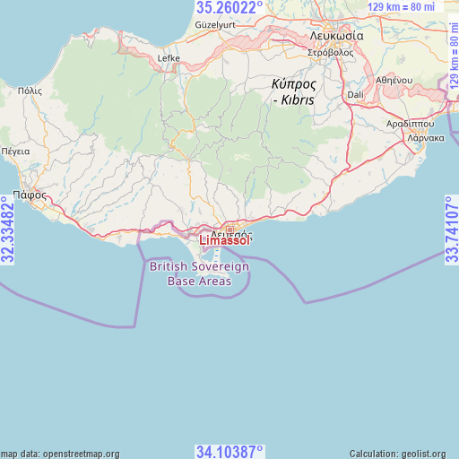
Limassol GPS coordinates[2]
34° 41' 2.616" North, 33° 2' 16.584" East
| Map corner | latitude | longitude |
|---|---|---|
| Upper-left | 35.26022°, | 32.33482° |
| Center: | 34.68406°, | 33.03794° |
| Lower-right: | 34.10387°, | 33.74107° |
| Map W x H: | 128.6×128.6 km | = 79.9×79.9mi |
| max Lat: | 35.59719° ⇑97.4% North |
| Limassol: | 34.68406° |
| min Lat: | ⇓2.6% South 34.66865° |
| min Long | Limassol | max Long |
| 32.38166° | 33.03794° | 34.37916° |
| W 39.3%⇐ | ⇒60.7% E |
Elevation
Elevation of Limassol is 27 m = 89 ft, and this is 181 m = 594 ft below average elevation for this country.
| Max E: |
1134 m = 3720 ft | 88.9% |
| Avg. | 208 m = 682 ft | |
| Limassol | 27 m = 89 ft | |
Min E: |
4 m = 13 ft | 11.1% |
See also: Limassol elevation on elevation.city.
Geographical zone
Limassol is located in North temperate zone (between Tropic of Cancer and the Arctic Circle). Distance of this Northern Tropic circle is 1250.6 km =777.1 mi to South.| Distance of | km | miles | from Limassol |
|---|---|---|---|
| North Pole | 6150.6 | 3821.8 | to North |
| Arctic Circle | 3544.7 | 2202.6 | to North |
| Tropic Cancer | 1250.6 | 777.1 | to South |
| Equator | 3856.5 | 2396.3 | to South |


Nearby cities:
15 places around Limassol: (largest is in red/bold)
• Avdímou
25.2 km =15.7 mi,  272°
272°
• Erími
11 km =6.8 mi, 266°
• Kalavasos
25.6 km =15.9 mi,  67°
67°
• Kolossi
9.7 km =6 mi,  259°
259°
• Mouttagiáka
7 km =4.3 mi,  54°
54°
• Palodeia
7.4 km =4.6 mi,  336°
336°
• Parekklisha
13 km =8.1 mi,  58°
58°
• Peléndri
24.4 km =15.2 mi, 344°
• Pyrgos
14.8 km =9.2 mi, 64°
• Páchna
24.7 km =15.3 mi,  295°
295°
• Páno Kivídes
18.4 km =11.4 mi, 296°
• Páno Polemídia
4.8 km =3 mi, 300°
• Sotíra
16.3 km =10.1 mi,  280°
280°
• Ágios Týchon
10.3 km =6.4 mi, 63°
• Ýpsonas
7 km =4.3 mi, 273°
Sources, notices
• [Note1] Compared only with cities in Cyprus existing in our database
• [Src1] Map data: © OpenStreetMap contributors (CC-BY-SA)
• [Src2] Other city data from geonames.org with taken over terms of usage.
• [Src3] Geographical zone / Annual Mean Temperature by Robert A. Rohde @ Wikipedia
