Oroúnta geodata
Oroúnta (Nicosia) is a populated place; located in Cyprus in Asia/Nicosia (GMT+2) time zone. With population of 687 people, there are 98 cities with bigger population in this country. Compared to other cities in Cyprus, 82.9% of cities are located further ↓South; 59% of cities are located further →East and 76.9% of cities have lower elevation than Oroúnta. Note1


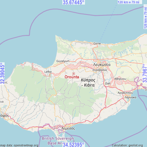
Oroúnta GPS coordinates[2]
35° 6' 4.428" North, 33° 5' 36.852" East
| Map corner | latitude | longitude |
|---|---|---|
| Upper-left | 35.67445°, | 32.39045° |
| Center: | 35.10123°, | 33.09357° |
| Lower-right: | 34.52395°, | 33.7967° |
| Map W x H: | 127.9×127.9 km | = 79.5×79.5mi |
| max Lat: | 35.59719° ⇑17.1% North |
| Oroúnta: | 35.10123° |
| min Lat: | ⇓82.9% South 34.66865° |
| min Long | Oroúnta | max Long |
| 32.38166° | 33.09357° | 34.37916° |
| W 41%⇐ | ⇒59% E |
Elevation
Elevation of Oroúnta is 300 m = 984 ft, and this is 92 m = 302 ft above average elevation for this country.
| Max E: |
1134 m = 3720 ft | 23.1% |
| Oroúnta | 300 m 984 ft | |
| Avg. | 208 m = 682 ft | |
Min E: |
4 m = 13 ft | 76.9% |
See also: Cyprus elevation on elevation.city.
Geographical zone
Oroúnta is located in North temperate zone (between Tropic of Cancer and the Arctic Circle). Distance of this Northern Tropic circle is 1297 km =805.9 mi to South.| Distance of | km | miles | from Oroúnta |
|---|---|---|---|
| North Pole | 6104.2 | 3793 | to North |
| Arctic Circle | 3498.3 | 2173.7 | to North |
| Tropic Cancer | 1297 | 805.9 | to South |
| Equator | 3902.9 | 2425.1 | to South |


Nearby cities:
15 places around Oroúnta: (largest is in red/bold)
• Akáki
4.8 km =3 mi,  41°
41°
• Aredioú
11 km =6.8 mi,  122°
122°
• Astromerítis
6.7 km =4.2 mi,  311°
311°
• Episkopeió
15.3 km =9.5 mi, 115°
• Ergátes
14.6 km =9.1 mi,  111°
111°
• Klírou
11.9 km =7.4 mi,  139°
139°
• Kokkinotrimithiá
11.2 km =7 mi,  59°
59°
• Mitseró
7.1 km =4.4 mi,  156°
156°
• Mámmari
13.1 km =8.1 mi,  50°
50°
• Méniko
4.7 km =2.9 mi,  78°
78°
• Mórfou
14.2 km =8.8 mi,  319°
319°
• Peristeróna
3.4 km =2.1 mi,  336°
336°
• Potámi
5.8 km =3.6 mi,  273°
273°
• Psimolofou
16 km =9.9 mi, 105°
• Páno Defterá
15.9 km =9.9 mi,  99°
99°
Sources, notices
• [Note1] Compared only with cities in Cyprus existing in our database
• [Src1] Map data: © OpenStreetMap contributors (CC-BY-SA)
• [Src2] Other city data from geonames.org with taken over terms of usage.
• [Src3] Geographical zone / Annual Mean Temperature by Robert A. Rohde @ Wikipedia
