Astromerítis geodata
Astromerítis (Nicosia) is a populated place; located in Cyprus in Asia/Nicosia (GMT+2) time zone. With population of 2,463 people, there are 42 cities with bigger population in this country. Compared to other cities in Cyprus, 89.7% of cities are located further ↓South; 61.5% of cities are located further →East and 56.4% of cities have lower elevation than Astromerítis. Note1


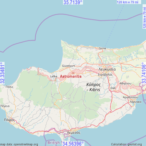
Astromerítis GPS coordinates[2]
35° 8' 27.456" North, 33° 2' 16.548" East
| Map corner | latitude | longitude |
|---|---|---|
| Upper-left | 35.7139°, | 32.33481° |
| Center: | 35.14096°, | 33.03793° |
| Lower-right: | 34.56396°, | 33.74106° |
| Map W x H: | 127.9×127.9 km | = 79.5×79.5mi |
| max Lat: | 35.59719° ⇑10.3% North |
| Astromerítis: | 35.14096° |
| min Lat: | ⇓89.7% South 34.66865° |
| min Long | Astromerítis | max Long |
| 32.38166° | 33.03793° | 34.37916° |
| W 38.5%⇐ | ⇒61.5% E |
Elevation
Elevation of Astromerítis is 158 m = 518 ft, and this is 50 m = 164 ft below average elevation for this country.
| Max E: |
1134 m = 3720 ft | 43.6% |
| Avg. | 208 m = 682 ft | |
| Astromerítis | 158 m = 518 ft | |
Min E: |
4 m = 13 ft | 56.4% |
See also: Cyprus elevation on elevation.city.
Geographical zone
Astromerítis is located in North temperate zone (between Tropic of Cancer and the Arctic Circle). Distance of this Northern Tropic circle is 1301.4 km =808.7 mi to South.| Distance of | km | miles | from Astromerítis |
|---|---|---|---|
| North Pole | 6099.8 | 3790.2 | to North |
| Arctic Circle | 3493.9 | 2171 | to North |
| Tropic Cancer | 1301.4 | 808.7 | to South |
| Equator | 3907.3 | 2427.9 | to South |


Nearby cities:
15 places around Astromerítis: (largest is in red/bold)
• Akáki
8.3 km =5.2 mi,  95°
95°
• Aredioú
17.7 km =11 mi,  125°
125°
• Evrýchou
16.6 km =10.3 mi,  228°
228°
• Galáta
20.4 km =12.7 mi,  218°
218°
• Klírou
18.5 km =11.5 mi,  136°
136°
• Kokkinotrimithiá
14.8 km =9.2 mi,  84°
84°
• Korákou
17.6 km =10.9 mi, 230°
• Léfka
17.4 km =10.8 mi,  259°
259°
• Mitseró
13.4 km =8.3 mi, 144°
• Mámmari
15.6 km =9.7 mi, 75°
• Méniko
10.3 km =6.4 mi,  109°
109°
• Mórfou
7.6 km =4.7 mi,  327°
327°
• Oroúnta
6.7 km =4.2 mi, 131°
• Peristeróna
3.9 km =2.4 mi, 109°
• Potámi
4.1 km =2.5 mi,  190°
190°
Sources, notices
• [Note1] Compared only with cities in Cyprus existing in our database
• [Src1] Map data: © OpenStreetMap contributors (CC-BY-SA)
• [Src2] Other city data from geonames.org with taken over terms of usage.
• [Src3] Geographical zone / Annual Mean Temperature by Robert A. Rohde @ Wikipedia
