Nicosia geodata
Nicosia is a capital of a political entity; located in Cyprus in Asia/Nicosia (GMT+2) time zone. With population of 200,452 people, there are 0 cities with bigger population in this country. Compared to other cities in Cyprus, 92.3% of cities are located further ↓South; 65% of cities are located further ←West and 54.7% of cities have lower elevation than Nicosia. Note1


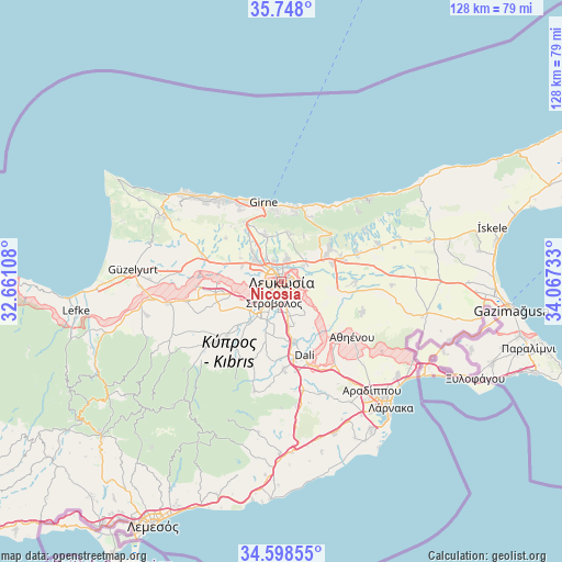
Nicosia GPS coordinates[2]
35° 10' 31.116" North, 33° 21' 51.12" East
| Map corner | latitude | longitude |
|---|---|---|
| Upper-left | 35.748°, | 32.66108° |
| Center: | 35.17531°, | 33.3642° |
| Lower-right: | 34.59855°, | 34.06733° |
| Map W x H: | 127.8×127.8 km | = 79.4×79.4mi |
| max Lat: | 35.59719° ⇑7.7% North |
| Nicosia: | 35.17531° |
| min Lat: | ⇓92.3% South 34.66865° |
| min Long | Nicosia | max Long |
| 32.38166° | 33.3642° | 34.37916° |
| W 65%⇐ | ⇒35% E |
Elevation
Elevation of Nicosia is 147 m = 482 ft, and this is 61 m = 200 ft below average elevation for this country.
| Max E: |
1134 m = 3720 ft | 45.3% |
| Avg. | 208 m = 682 ft | |
| Nicosia | 147 m = 482 ft | |
Min E: |
4 m = 13 ft | 54.7% |
See also: Nicosia elevation on elevation.city.
Geographical zone
Nicosia is located in North temperate zone (between Tropic of Cancer and the Arctic Circle). Distance of this Northern Tropic circle is 1305.2 km =811 mi to South.| Distance of | km | miles | from Nicosia |
|---|---|---|---|
| North Pole | 6095.9 | 3787.8 | to North |
| Arctic Circle | 3490 | 2168.6 | to North |
| Tropic Cancer | 1305.2 | 811 | to South |
| Equator | 3911.1 | 2430.2 | to South |


Nearby cities:
15 places around Nicosia: (largest is in red/bold)
• Alámpra
21 km =13 mi,  171°
171°
• Aredioú
20.8 km =12.9 mi,  227°
227°
• Athíenou
20.5 km =12.7 mi,  128°
128°
• Dáli
17.7 km =11 mi,  162°
162°
• Episkopeió
18.3 km =11.4 mi,  216°
216°
• Ergátes
17.5 km =10.9 mi, 219°
• Géri
9.3 km =5.8 mi,  146°
146°
• Kokkinotrimithiá
15.2 km =9.4 mi,  260°
260°
• Kyrenia
18.4 km =11.4 mi,  346°
346°
• Káto Defterá
12.9 km =8 mi, 218°
• Mámmari
14.5 km =9 mi,  270°
270°
• Psimolofou
15.6 km =9.7 mi, 216°
• Páno Defterá
14.1 km =8.8 mi, 219°
• Péra
18.7 km =11.6 mi,  212°
212°
• Tséri
12 km =7.5 mi,  198°
198°
Sources, notices
• [Note1] Compared only with cities in Cyprus existing in our database
• [Src1] Map data: © OpenStreetMap contributors (CC-BY-SA)
• [Src2] Other city data from geonames.org with taken over terms of usage.
• [Src3] Geographical zone / Annual Mean Temperature by Robert A. Rohde @ Wikipedia
