Athíenou geodata
Athíenou (Larnaka) is a populated place; located in Cyprus in Asia/Nicosia (GMT+3) time zone. With population of 4,444 people, there are 25 cities with bigger population in this country. Compared to other cities in Cyprus, 76.1% of cities are located further ↓South; 76.1% of cities are located further ←West and 53.8% of cities have lower elevation than Athíenou. Note1


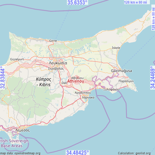
Athíenou GPS coordinates[2]
35° 3' 42.48" North, 33° 32' 29.616" East
| Map corner | latitude | longitude |
|---|---|---|
| Upper-left | 35.6353°, | 32.83844° |
| Center: | 35.0618°, | 33.54156° |
| Lower-right: | 34.48425°, | 34.24469° |
| Map W x H: | 128×128 km | = 79.5×79.5mi |
| max Lat: | 35.59719° ⇑23.9% North |
| Athíenou: | 35.0618° |
| min Lat: | ⇓76.1% South 34.66865° |
| min Long | Athíenou | max Long |
| 32.38166° | 33.54156° | 34.37916° |
| W 76.1%⇐ | ⇒23.9% E |
Elevation
Elevation of Athíenou is 146 m = 479 ft, and this is 62 m = 203 ft below average elevation for this country.
| Max E: |
1134 m = 3720 ft | 46.2% |
| Avg. | 208 m = 682 ft | |
| Athíenou | 146 m = 479 ft | |
Min E: |
4 m = 13 ft | 53.8% |
See also: Cyprus elevation on elevation.city.
Geographical zone
Athíenou is located in North temperate zone (between Tropic of Cancer and the Arctic Circle). Distance of this Northern Tropic circle is 1292.6 km =803.2 mi to South.| Distance of | km | miles | from Athíenou |
|---|---|---|---|
| North Pole | 6108.6 | 3795.7 | to North |
| Arctic Circle | 3502.7 | 2176.5 | to North |
| Tropic Cancer | 1292.6 | 803.2 | to South |
| Equator | 3898.5 | 2422.4 | to South |


Nearby cities:
15 places around Athíenou: (largest is in red/bold)
• Alámpra
15.3 km =9.5 mi,  238°
238°
• Aradíppou
13.1 km =8.1 mi,  159°
159°
• Dáli
11.7 km =7.3 mi,  248°
248°
• Géri
12.1 km =7.5 mi,  293°
293°
• Larnaca
17.1 km =10.6 mi,  154°
154°
• Livádia
14.5 km =9 mi, 147°
• Lýmpia
10.1 km =6.3 mi,  226°
226°
• Mosfilotí
16.1 km =10 mi,  221°
221°
• Psevdás
14.7 km =9.1 mi,  209°
209°
• Pérgamos
15.3 km =9.5 mi,  98°
98°
• Pýla
14.7 km =9.1 mi,  111°
111°
• Siá
18.2 km =11.3 mi, 229°
• Troúlloi
7.5 km =4.7 mi,  116°
116°
• Voróklini
13.3 km =8.3 mi,  129°
129°
• Xylotymbou
18.9 km =11.7 mi, 105°
Sources, notices
• [Note1] Compared only with cities in Cyprus existing in our database
• [Src1] Map data: © OpenStreetMap contributors (CC-BY-SA)
• [Src2] Other city data from geonames.org with taken over terms of usage.
• [Src3] Geographical zone / Annual Mean Temperature by Robert A. Rohde @ Wikipedia
