Evrýchou geodata
Evrýchou (Nicosia) is a populated place; located in Cyprus in Asia/Nicosia (GMT+2) time zone. With population of 855 people, there are 90 cities with bigger population in this country. Compared to other cities in Cyprus, 70.1% of cities are located further ↓South; 71.8% of cities are located further →East and 88% of cities have lower elevation than Evrýchou. Note1


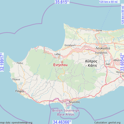
Evrýchou GPS coordinates[2]
35° 2' 28.896" North, 32° 54' 8.244" East
| Map corner | latitude | longitude |
|---|---|---|
| Upper-left | 35.615°, | 32.19917° |
| Center: | 35.04136°, | 32.90229° |
| Lower-right: | 34.46366°, | 33.60542° |
| Map W x H: | 128×128 km | = 79.5×79.5mi |
| max Lat: | 35.59719° ⇑29.9% North |
| Evrýchou: | 35.04136° |
| min Lat: | ⇓70.1% South 34.66865° |
| min Long | Evrýchou | max Long |
| 32.38166° | 32.90229° | 34.37916° |
| W 28.2%⇐ | ⇒71.8% E |
Elevation
Elevation of Evrýchou is 447 m = 1467 ft, and this is 239 m = 784 ft above average elevation for this country.
| Max E: |
1134 m = 3720 ft | 12% |
| Evrýchou | 447 m 1467 ft | |
| Avg. | 208 m = 682 ft | |
Min E: |
4 m = 13 ft | 88% |
See also: Cyprus elevation on elevation.city.
Geographical zone
Evrýchou is located in North temperate zone (between Tropic of Cancer and the Arctic Circle). Distance of this Northern Tropic circle is 1290.3 km =801.8 mi to South.| Distance of | km | miles | from Evrýchou |
|---|---|---|---|
| North Pole | 6110.8 | 3797.1 | to North |
| Arctic Circle | 3504.9 | 2177.8 | to North |
| Tropic Cancer | 1290.3 | 801.8 | to South |
| Equator | 3896.2 | 2421 | to South |


Nearby cities:
15 places around Evrýchou: (largest is in red/bold)
• Agrós
17.3 km =10.7 mi,  142°
142°
• Akáki
23 km =14.3 mi,  63°
63°
• Astromerítis
16.6 km =10.3 mi,  48°
48°
• Galáta
4.9 km =3 mi,  183°
183°
• Kakopetriá
6 km =3.7 mi, 177°
• Korákou
1.4 km =0.9 mi,  268°
268°
• Kyperoúnta
13.3 km =8.3 mi,  149°
149°
• Léfka
9.2 km =5.7 mi,  328°
328°
• Mitseró
20.2 km =12.6 mi,  89°
89°
• Méniko
23.3 km =14.5 mi,  71°
71°
• Mórfou
19.4 km =12.1 mi,  25°
25°
• Oroúnta
18.6 km =11.6 mi, 69°
• Peléndri
17.2 km =10.7 mi,  159°
159°
• Peristeróna
18.8 km =11.7 mi, 58°
• Potámi
13.6 km =8.5 mi, 58°
Sources, notices
• [Note1] Compared only with cities in Cyprus existing in our database
• [Src1] Map data: © OpenStreetMap contributors (CC-BY-SA)
• [Src2] Other city data from geonames.org with taken over terms of usage.
• [Src3] Geographical zone / Annual Mean Temperature by Robert A. Rohde @ Wikipedia
