Český Těšín geodata
Český Těšín (Moravskoslezský) is a seat of a third-order administrative division; located in Czech Republic in Europe/Prague (GMT+2) time zone. With population of 25,750 people, there are 48 cities with bigger population in this country. Compared to other cities in Czech Republic, 51% of cities are located further ↑North; 99.5% of cities are located further ←West and 64.6% of cities have higher elevation than Český Těšín. Note1


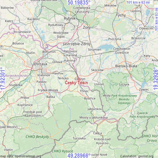
Český Těšín GPS coordinates[2]
49° 44' 46.068" North, 18° 37' 34.068" East
| Map corner | latitude | longitude |
|---|---|---|
| Upper-left | 50.19835°, | 17.92301° |
| Center: | 49.74613°, | 18.62613° |
| Lower-right: | 49.28966°, | 19.32926° |
| Map W x H: | 101×101 km | = 62.8×62.8mi |
| max Lat: | 51.01104° ⇑51% North |
| Český Těšín: | 49.74613° |
| min Lat: | ⇓49% South 48.60378° |
| min Long | Český Těší | max Long |
| 12.17577° | 18.62613° | 18.82683° |
| W 99.5%⇐ | ⇒0.5% E |
Elevation
Elevation of Český Těšín is 275 m = 902 ft, and this is 77 m = 253 ft below average elevation for this country.
| Max E: |
901 m = 2956 ft | 64.6% |
| Avg. | 352 m = 1155 ft | |
| Český Těšín | 275 m = 902 ft | |
Min E: |
136 m = 446 ft | 35.4% |
See also: Czech Republic elevation on elevation.city.
Geographical zone
Český Těšín is located in North temperate zone (between Tropic of Cancer and the Arctic Circle). Distance of this North polar circle is 1869.9 km =1161.9 mi to North.| Distance of | km | miles | from Český Těšín |
|---|---|---|---|
| North Pole | 4475.8 | 2781.1 | to North |
| Arctic Circle | 1869.9 | 1161.9 | to North |
| Tropic Cancer | 2925.3 | 1817.7 | to South |
| Equator | 5531.3 | 3437 | to South |


Nearby cities:
15 places around Český Těšín: (largest is in red/bold)
• Albrechtice
8.6 km =5.3 mi,  301°
301°
• Chotěbuz
4.8 km =3 mi, 301°
• Dolní Domaslavice
11.4 km =7.1 mi,  249°
249°
• Hnojník
9.3 km =5.8 mi,  220°
220°
• Horní Domaslavice
13.2 km =8.2 mi,  244°
244°
• Horní Suchá
11.8 km =7.3 mi, 299°
• Horní Těrlicko
10.3 km =6.4 mi,  273°
273°
• Komorní Lhotka
12.1 km =7.5 mi, 215°
• Lučina
13.1 km =8.1 mi,  257°
257°
• Ropice
4.6 km =2.9 mi,  191°
191°
• Smilovice
10.3 km =6.4 mi,  202°
202°
• Stonava
10.7 km =6.6 mi,  317°
317°
• Střítež
8.5 km =5.3 mi,  208°
208°
• Třinec
8.3 km =5.2 mi,  157°
157°
• Vendryně
10.8 km =6.7 mi,  144°
144°
Sources, notices
• [Note1] Compared only with cities in Czech Republic existing in our database
• [Src1] Map data: © OpenStreetMap contributors (CC-BY-SA)
• [Src2] Other city data from geonames.org with taken over terms of usage.
• [Src3] Geographical zone / Annual Mean Temperature by Robert A. Rohde @ Wikipedia
