Zotzenheim geodata
Zotzenheim (Rheinland-Pfalz) is a seat of a fourth-order administrative division; located in Germany in Europe/Berlin (GMT+2) time zone. With population of 646 people, there are 8576 cities with bigger population in this country. Compared to other cities in Germany, 67.4% of cities are located further ↑North; 77.8% of cities are located further →East and 66% of cities have higher elevation than Zotzenheim. Note1
Administrative division(s):
- Level 1: Rheinland-Pfalz
- Level 3: Landkreis Mainz-Bingen
- Level 4: Zotzenheim


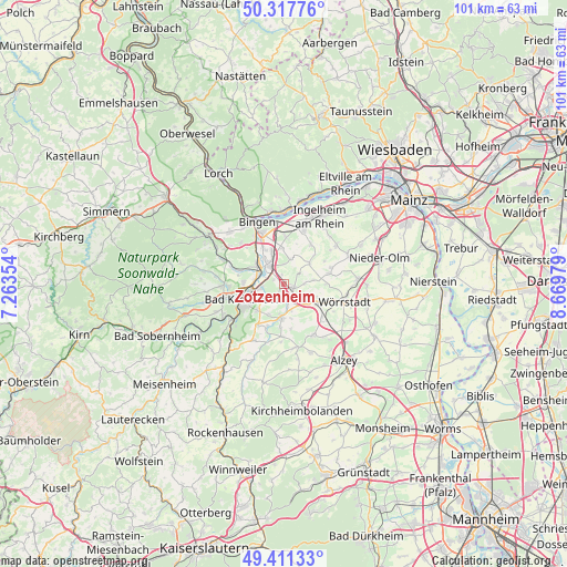
Zotzenheim GPS coordinates[2]
49° 52' 0.012" North, 7° 58' 0.012" East
| Map corner | latitude | longitude |
|---|---|---|
| Upper-left | 50.31776°, | 7.26354° |
| Center: | 49.86667°, | 7.96667° |
| Lower-right: | 49.41133°, | 8.66979° |
| Map W x H: | 100.8×100.8 km | = 62.6×62.6mi |
| max Lat: | 55.01917° ⇑67.4% North |
| Zotzenheim: | 49.86667° |
| min Lat: | ⇓32.6% South 47.40724° |
| min Long | Zotzenheim | max Long |
| 5.92978° | 7.96667° | 14.98853° |
| W 22.2%⇐ | ⇒77.8% E |
Elevation
Elevation of Zotzenheim is 114 m = 374 ft, and this is 135.1 m = 443 ft below average elevation for this country.
| Max E: |
1256 m = 4121 ft | 66% |
| Avg. | 249.1 m = 817 ft | |
| Zotzenheim | 114 m = 374 ft | |
Min E: |
-5 m = -16 ft | 34% |
See also: Germany elevation on elevation.city.
Geographical zone
Zotzenheim is located in North temperate zone (between Tropic of Cancer and the Arctic Circle). Distance of this North polar circle is 1856.5 km =1153.6 mi to North.| Distance of | km | miles | from Zotzenheim |
|---|---|---|---|
| North Pole | 4462.4 | 2772.8 | to North |
| Arctic Circle | 1856.5 | 1153.6 | to North |
| Tropic Cancer | 2938.7 | 1826 | to South |
| Equator | 5544.7 | 3445.3 | to South |


Nearby cities:
15 places around Zotzenheim: (largest is in red/bold)
• Aspisheim
3.9 km =2.4 mi,  17°
17°
• Badenheim
3.7 km =2.3 mi,  180°
180°
• Biebelsheim
2.4 km =1.5 mi,  270°
270°
• Bretzenheim
5.2 km =3.2 mi,  284°
284°
• Gau-Bickelheim
5.2 km =3.2 mi,  132°
132°
• Gensingen
4.4 km =2.7 mi,  327°
327°
• Gumbsheim
5.7 km =3.5 mi,  167°
167°
• Horrweiler
3.7 km =2.3 mi,  0°
0°
• Pfaffen-Schwabenheim
2.2 km =1.4 mi,  212°
212°
• Pleitersheim
3.9 km =2.4 mi,  197°
197°
• Sankt Johann
3.4 km =2.1 mi,  88°
88°
• Sprendlingen
1.2 km =0.7 mi, 90°
• Welgesheim
1.9 km =1.2 mi, 0°
• Wolfsheim
5.3 km =3.3 mi,  83°
83°
• Wöllstein
5.6 km =3.5 mi, 180°
Sources, notices
• [Note1] Compared only with cities in Germany existing in our database
• [Src1] Map data: © OpenStreetMap contributors (CC-BY-SA)
• [Src2] Other city data from geonames.org with taken over terms of usage.
• [Src3] Geographical zone / Annual Mean Temperature by Robert A. Rohde @ Wikipedia
