Aspisheim geodata
Aspisheim (Rheinland-Pfalz) is a seat of a fourth-order administrative division; located in Germany in Europe/Berlin (GMT+2) time zone. With population of 973 people, there are 7261 cities with bigger population in this country. Compared to other cities in Germany, 66.6% of cities are located further ↑North; 77.5% of cities are located further →East and 50.3% of cities have higher elevation than Aspisheim. Note1
Administrative division(s):
- Level 1: Rheinland-Pfalz
- Level 3: Landkreis Mainz-Bingen
- Level 4: Aspisheim


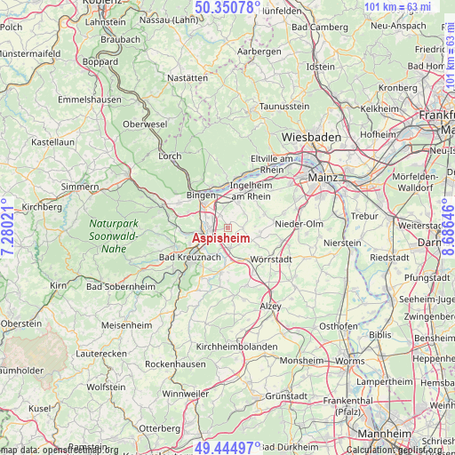
Aspisheim GPS coordinates[2]
49° 54' 0" North, 7° 58' 59.988" East
| Map corner | latitude | longitude |
|---|---|---|
| Upper-left | 50.35078°, | 7.28021° |
| Center: | 49.9°, | 7.98333° |
| Lower-right: | 49.44497°, | 8.68646° |
| Map W x H: | 100.7×100.7 km | = 62.6×62.6mi |
| max Lat: | 55.01917° ⇑66.6% North |
| Aspisheim: | 49.9° |
| min Lat: | ⇓33.4% South 47.40724° |
| min Long | Aspisheim | max Long |
| 5.92978° | 7.98333° | 14.98853° |
| W 22.5%⇐ | ⇒77.5% E |
Elevation
Elevation of Aspisheim is 223 m = 732 ft, and this is 26.1 m = 86 ft below average elevation for this country.
| Max E: |
1256 m = 4121 ft | 50.3% |
| Avg. | 249.1 m = 817 ft | |
| Aspisheim | 223 m = 732 ft | |
Min E: |
-5 m = -16 ft | 49.7% |
See also: Germany elevation on elevation.city.
Geographical zone
Aspisheim is located in North temperate zone (between Tropic of Cancer and the Arctic Circle). Distance of this North polar circle is 1852.8 km =1151.3 mi to North.| Distance of | km | miles | from Aspisheim |
|---|---|---|---|
| North Pole | 4458.7 | 2770.5 | to North |
| Arctic Circle | 1852.8 | 1151.3 | to North |
| Tropic Cancer | 2942.4 | 1828.3 | to South |
| Equator | 5548.4 | 3447.6 | to South |


Nearby cities:
15 places around Aspisheim: (largest is in red/bold)
• Appenheim
4.9 km =3 mi,  47°
47°
• Biebelsheim
5.2 km =3.2 mi,  224°
224°
• Engelstadt
5.9 km =3.7 mi,  85°
85°
• Gensingen
3.6 km =2.2 mi,  270°
270°
• Grolsheim
4.9 km =3 mi,  280°
280°
• Horrweiler
1.2 km =0.7 mi, 270°
• Langenlonsheim
6 km =3.7 mi, 270°
• Nieder-Hilbersheim
4.5 km =2.8 mi,  70°
70°
• Ober-Hilbersheim
3.3 km =2.1 mi, 90°
• Ockenheim
4.9 km =3 mi,  349°
349°
• Sankt Johann
4.2 km =2.6 mi,  148°
148°
• Sprendlingen
3.7 km =2.3 mi,  180°
180°
• Welgesheim
2.2 km =1.4 mi,  212°
212°
• Wolfsheim
5.1 km =3.2 mi,  127°
127°
• Zotzenheim
3.9 km =2.4 mi,  197°
197°
Sources, notices
• [Note1] Compared only with cities in Germany existing in our database
• [Src1] Map data: © OpenStreetMap contributors (CC-BY-SA)
• [Src2] Other city data from geonames.org with taken over terms of usage.
• [Src3] Geographical zone / Annual Mean Temperature by Robert A. Rohde @ Wikipedia
