Bretzenheim geodata
Bretzenheim (Rheinland-Pfalz) is a seat of a fourth-order administrative division; located in Germany in Europe/Berlin (GMT+2) time zone. With population of 2,455 people, there are 4496 cities with bigger population in this country. Compared to other cities in Germany, 67% of cities are located further ↑North; 79.1% of cities are located further →East and 66.3% of cities have higher elevation than Bretzenheim. Note1
Administrative division(s):
- Level 1: Rheinland-Pfalz
- Level 3: Landkreis Bad Kreuznach
- Level 4: Bretzenheim


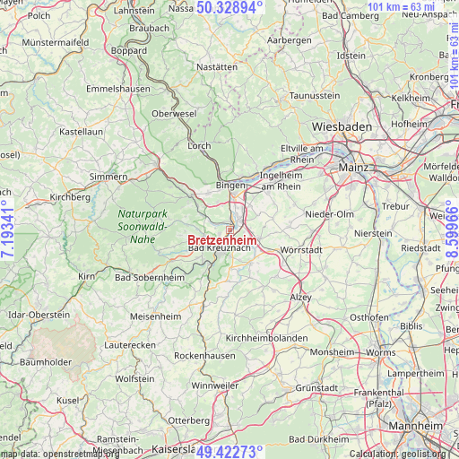
Bretzenheim GPS coordinates[2]
49° 52' 40.656" North, 7° 53' 47.508" East
| Map corner | latitude | longitude |
|---|---|---|
| Upper-left | 50.32894°, | 7.19341° |
| Center: | 49.87796°, | 7.89653° |
| Lower-right: | 49.42273°, | 8.59966° |
| Map W x H: | 100.8×100.8 km | = 62.6×62.6mi |
| max Lat: | 55.01917° ⇑67% North |
| Bretzenheim: | 49.87796° |
| min Lat: | ⇓33% South 47.40724° |
| min Long | Bretzenheim | max Long |
| 5.92978° | 7.89653° | 14.98853° |
| W 20.9%⇐ | ⇒79.1% E |
Elevation
Elevation of Bretzenheim is 112 m = 367 ft, and this is 137.1 m = 450 ft below average elevation for this country.
| Max E: |
1256 m = 4121 ft | 66.3% |
| Avg. | 249.1 m = 817 ft | |
| Bretzenheim | 112 m = 367 ft | |
Min E: |
-5 m = -16 ft | 33.7% |
See also: Germany elevation on elevation.city.
Geographical zone
Bretzenheim is located in North temperate zone (between Tropic of Cancer and the Arctic Circle). Distance of this North polar circle is 1855.3 km =1152.8 mi to North.| Distance of | km | miles | from Bretzenheim |
|---|---|---|---|
| North Pole | 4461.2 | 2772.1 | to North |
| Arctic Circle | 1855.3 | 1152.8 | to North |
| Tropic Cancer | 2940 | 1826.8 | to South |
| Equator | 5545.9 | 3446.1 | to South |


Nearby cities:
15 places around Bretzenheim: (largest is in red/bold)
• Bad Kreuznach
4.6 km =2.9 mi,  207°
207°
• Biebelsheim
2.9 km =1.8 mi,  115°
115°
• Dorsheim
5.5 km =3.4 mi,  342°
342°
• Gensingen
3.6 km =2.2 mi,  47°
47°
• Grolsheim
3.7 km =2.3 mi,  22°
22°
• Hackenheim
5.9 km =3.7 mi,  178°
178°
• Hargesheim
5.2 km =3.2 mi,  250°
250°
• Horrweiler
5.6 km =3.5 mi,  64°
64°
• Langenlonsheim
2.5 km =1.6 mi,  5°
5°
• Laubenheim
4.3 km =2.7 mi,  3°
3°
• Pfaffen-Schwabenheim
4.9 km =3 mi,  129°
129°
• Sprendlingen
6.3 km =3.9 mi,  101°
101°
• Welgesheim
5.1 km =3.2 mi,  83°
83°
• Windesheim
6.2 km =3.9 mi,  293°
293°
• Zotzenheim
5.2 km =3.2 mi, 104°
Sources, notices
• [Note1] Compared only with cities in Germany existing in our database
• [Src1] Map data: © OpenStreetMap contributors (CC-BY-SA)
• [Src2] Other city data from geonames.org with taken over terms of usage.
• [Src3] Geographical zone / Annual Mean Temperature by Robert A. Rohde @ Wikipedia
