Ziegenrück geodata
Ziegenrück (Thuringia) is a populated place; located in Germany in Europe/Berlin (GMT+2) time zone. With population of 784 people, there are 7970 cities with bigger population in this country. Compared to other cities in Germany, 50.3% of cities are located further ↑North; 76.4% of cities are located further ←West and 64.7% of cities have lower elevation than Ziegenrück. Note1


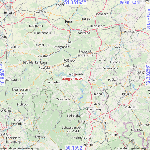
Ziegenrück GPS coordinates[2]
50° 36' 27.144" North, 11° 38' 59.388" East
| Map corner | latitude | longitude |
|---|---|---|
| Upper-left | 51.05165°, | 10.94671° |
| Center: | 50.60754°, | 11.64983° |
| Lower-right: | 50.1592°, | 12.35296° |
| Map W x H: | 99.2×99.2 km | = 61.6×61.6mi |
| max Lat: | 55.01917° ⇑50.3% North |
| Ziegenrück: | 50.60754° |
| min Lat: | ⇓49.7% South 47.40724° |
| min Long | Ziegenrück | max Long |
| 5.92978° | 11.64983° | 14.98853° |
| W 76.4%⇐ | ⇒23.6% E |
Elevation
Elevation of Ziegenrück is 319 m = 1047 ft, and this is 69.9 m = 229 ft above average elevation for this country.
| Max E: |
1256 m = 4121 ft | 35.3% |
| Ziegenrück | 319 m 1047 ft | |
| Avg. | 249.1 m = 817 ft | |
Min E: |
-5 m = -16 ft | 64.7% |
See also: Germany elevation on elevation.city.
Geographical zone
Ziegenrück is located in North temperate zone (between Tropic of Cancer and the Arctic Circle). Distance of this North polar circle is 1774.1 km =1102.4 mi to North.| Distance of | km | miles | from Ziegenrück |
|---|---|---|---|
| North Pole | 4380 | 2721.6 | to North |
| Arctic Circle | 1774.1 | 1102.4 | to North |
| Tropic Cancer | 3021.1 | 1877.2 | to South |
| Equator | 5627 | 3496.5 | to South |


Nearby cities:
15 places around Ziegenrück: (largest is in red/bold)
• Altenbeuthen
3.9 km =2.4 mi,  243°
243°
• Bucha
4.6 km =2.9 mi,  50°
50°
• Crispendorf
6.2 km =3.9 mi,  106°
106°
• Drognitz
5.9 km =3.7 mi,  248°
248°
• Eßbach
3.6 km =2.2 mi,  138°
138°
• Grobengereuth
7 km =4.3 mi,  11°
11°
• Gössitz
4.8 km =3 mi,  289°
289°
• Keila
3.4 km =2.1 mi, 14°
• Knau
6.8 km =4.2 mi, 45°
• Moxa
4.9 km =3 mi,  346°
346°
• Paska
2 km =1.2 mi,  313°
313°
• Peuschen
5.7 km =3.5 mi,  356°
356°
• Schmorda
6.1 km =3.8 mi, 312°
• Schöndorf
3.4 km =2.1 mi,  70°
70°
• Volkmannsdorf
5.8 km =3.6 mi,  86°
86°
Sources, notices
• [Note1] Compared only with cities in Germany existing in our database
• [Src1] Map data: © OpenStreetMap contributors (CC-BY-SA)
• [Src2] Other city data from geonames.org with taken over terms of usage.
• [Src3] Geographical zone / Annual Mean Temperature by Robert A. Rohde @ Wikipedia
