Knau geodata
Knau (Thuringia) is a seat of a fourth-order administrative division; located in Germany in Europe/Berlin (GMT+2) time zone. With population of 692 people, there are 8351 cities with bigger population in this country. Compared to other cities in Germany, 50.9% of cities are located further ↓South; 77.5% of cities are located further ←West and 83.9% of cities have lower elevation than Knau. Note1


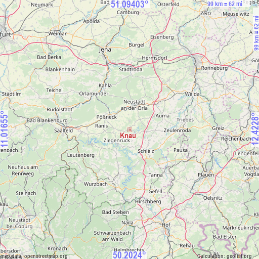
Knau GPS coordinates[2]
50° 39' 1.188" North, 11° 43' 10.812" East
| Map corner | latitude | longitude |
|---|---|---|
| Upper-left | 51.09403°, | 11.01655° |
| Center: | 50.65033°, | 11.71967° |
| Lower-right: | 50.2024°, | 12.4228° |
| Map W x H: | 99.1×99.1 km | = 61.6×61.6mi |
| max Lat: | 55.01917° ⇑49.1% North |
| Knau: | 50.65033° |
| min Lat: | ⇓50.9% South 47.40724° |
| min Long | Knau | max Long |
| 5.92978° | 11.71967° | 14.98853° |
| W 77.5%⇐ | ⇒22.5% E |
Elevation
Elevation of Knau is 461 m = 1512 ft, and this is 211.9 m = 695 ft above average elevation for this country.
| Max E: |
1256 m = 4121 ft | 16.1% |
| Knau | 461 m 1512 ft | |
| Avg. | 249.1 m = 817 ft | |
Min E: |
-5 m = -16 ft | 83.9% |
See also: Germany elevation on elevation.city.
Geographical zone
Knau is located in North temperate zone (between Tropic of Cancer and the Arctic Circle). Distance of this North polar circle is 1769.4 km =1099.5 mi to North.| Distance of | km | miles | from Knau |
|---|---|---|---|
| North Pole | 4375.3 | 2718.7 | to North |
| Arctic Circle | 1769.4 | 1099.5 | to North |
| Tropic Cancer | 3025.9 | 1880.2 | to South |
| Equator | 5631.8 | 3499.4 | to South |


Nearby cities:
15 places around Knau: (largest is in red/bold)
• Bucha
2.3 km =1.4 mi,  216°
216°
• Crispendorf
6.6 km =4.1 mi,  171°
171°
• Dreba
2.8 km =1.7 mi,  49°
49°
• Gertewitz
6.1 km =3.8 mi,  306°
306°
• Grobengereuth
4.1 km =2.5 mi,  300°
300°
• Keila
4.3 km =2.7 mi,  250°
250°
• Moxa
6.1 km =3.8 mi,  269°
269°
• Oberoppurg
6.1 km =3.8 mi,  335°
335°
• Peuschen
5.4 km =3.4 mi,  280°
280°
• Plothen
3.8 km =2.4 mi,  119°
119°
• Quaschwitz
3.9 km =2.4 mi, 339°
• Schöndorf
4.1 km =2.5 mi,  205°
205°
• Solkwitz
6.7 km =4.2 mi,  325°
325°
• Volkmannsdorf
4.5 km =2.8 mi, 169°
• Weira
5.5 km =3.4 mi,  357°
357°
Sources, notices
• [Note1] Compared only with cities in Germany existing in our database
• [Src1] Map data: © OpenStreetMap contributors (CC-BY-SA)
• [Src2] Other city data from geonames.org with taken over terms of usage.
• [Src3] Geographical zone / Annual Mean Temperature by Robert A. Rohde @ Wikipedia
