Moxa geodata
Moxa (Thuringia) is a seat of a fourth-order administrative division; located in Germany in Europe/Berlin (GMT+2) time zone. With population of 98 people, there are 10843 cities with bigger population in this country. Compared to other cities in Germany, 50.7% of cities are located further ↓South; 76.2% of cities are located further ←West and 84.9% of cities have lower elevation than Moxa. Note1


Moxa GPS coordinates[2]
50° 39' 0" North, 11° 37' 59.988" East
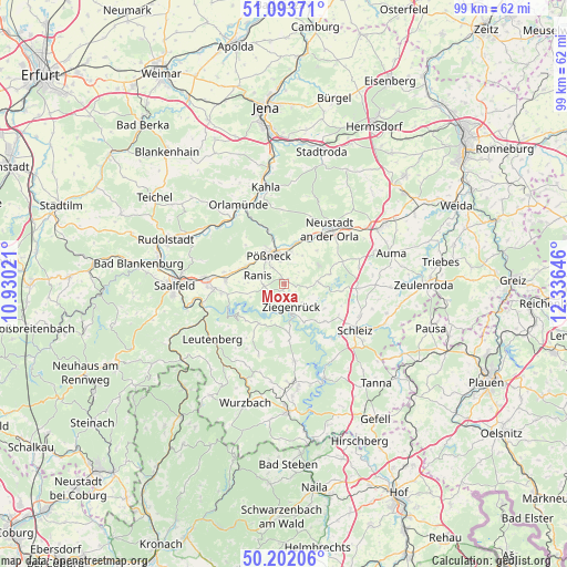
| Map corner | latitude | longitude |
|---|---|---|
| Upper-left | 51.09371°, | 10.93021° |
| Center: | 50.65°, | 11.63333° |
| Lower-right: | 50.20206°, | 12.33646° |
| Map W x H: | 99.1×99.1 km | = 61.6×61.6mi |
| max Lat: | 55.01917° ⇑49.3% North |
| Moxa: | 50.65° |
| min Lat: | ⇓50.7% South 47.40724° |
| min Long | Moxa | max Long |
| 5.92978° | 11.63333° | 14.98853° |
| W 76.2%⇐ | ⇒23.8% E |
Elevation
Elevation of Moxa is 468 m = 1535 ft, and this is 218.9 m = 718 ft above average elevation for this country.
| Max E: |
1256 m = 4121 ft | 15.1% |
| Moxa | 468 m 1535 ft | |
| Avg. | 249.1 m = 817 ft | |
Min E: |
-5 m = -16 ft | 84.9% |
See also: Germany elevation on elevation.city.
Geographical zone
Moxa is located in North temperate zone (between Tropic of Cancer and the Arctic Circle). Distance of this North polar circle is 1769.4 km =1099.5 mi to North.| Distance of | km | miles | from Moxa |
|---|---|---|---|
| North Pole | 4375.3 | 2718.7 | to North |
| Arctic Circle | 1769.4 | 1099.5 | to North |
| Tropic Cancer | 3025.8 | 1880.1 | to South |
| Equator | 5631.8 | 3499.4 | to South |


Nearby cities:
15 places around Moxa: (largest is in red/bold)
• Bodelwitz
4.2 km =2.6 mi,  349°
349°
• Bucha
5.1 km =3.2 mi,  111°
111°
• Gertewitz
3.9 km =2.4 mi,  17°
17°
• Grobengereuth
3.3 km =2.1 mi,  50°
50°
• Gössitz
4.5 km =2.8 mi,  226°
226°
• Keila
2.5 km =1.6 mi,  124°
124°
• Nimritz
5.7 km =3.5 mi,  11°
11°
• Paska
3.4 km =2.1 mi,  185°
185°
• Peuschen
1.3 km =0.8 mi,  39°
39°
• Pößneck
5.6 km =3.5 mi,  329°
329°
• Ranis
4.7 km =2.9 mi,  285°
285°
• Schmorda
3.4 km =2.1 mi,  260°
260°
• Schöndorf
5.6 km =3.5 mi,  129°
129°
• Wernburg
3.8 km =2.4 mi,  324°
324°
• Ziegenrück
4.9 km =3 mi,  166°
166°
Sources, notices
• [Note1] Compared only with cities in Germany existing in our database
• [Src1] Map data: © OpenStreetMap contributors (CC-BY-SA)
• [Src2] Other city data from geonames.org with taken over terms of usage.
• [Src3] Geographical zone / Annual Mean Temperature by Robert A. Rohde @ Wikipedia
