Wustrow geodata
Wustrow (Mecklenburg-Vorpommern) is a populated place; located in Germany in Europe/Berlin (GMT+2) time zone. With population of 1,312 people, there are 6272 cities with bigger population in this country. Compared to other cities in Germany, 85.3% of cities are located further ↓South; 93.4% of cities are located further ←West and 90.1% of cities have higher elevation than Wustrow. Note1
Administrative division(s):
- Level 1: Mecklenburg-Vorpommern
- Level 3: Mecklenburgische Seenplatte
- Level 4: Penzlin


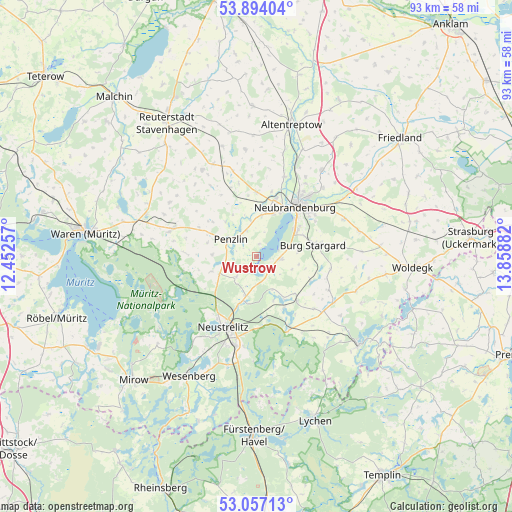
Wustrow GPS coordinates[2]
53° 28' 39.54" North, 13° 9' 20.484" East
| Map corner | latitude | longitude |
|---|---|---|
| Upper-left | 53.89404°, | 12.45257° |
| Center: | 53.47765°, | 13.15569° |
| Lower-right: | 53.05713°, | 13.85882° |
| Map W x H: | 93.1×93.1 km | = 57.8×57.8mi |
| max Lat: | 55.01917° ⇑14.7% North |
| Wustrow: | 53.47765° |
| min Lat: | ⇓85.3% South 47.40724° |
| min Long | Wustrow | max Long |
| 5.92978° | 13.15569° | 14.98853° |
| W 93.4%⇐ | ⇒6.6% E |
Elevation
Elevation of Wustrow is 21 m = 69 ft, and this is 228.1 m = 748 ft below average elevation for this country.
| Max E: |
1256 m = 4121 ft | 90.1% |
| Avg. | 249.1 m = 817 ft | |
| Wustrow | 21 m = 69 ft | |
Min E: |
-5 m = -16 ft | 9.9% |
See also: Germany elevation on elevation.city.
Geographical zone
Wustrow is located in North temperate zone (between Tropic of Cancer and the Arctic Circle). Distance of this North polar circle is 1455 km =904.1 mi to North.| Distance of | km | miles | from Wustrow |
|---|---|---|---|
| North Pole | 4060.9 | 2523.3 | to North |
| Arctic Circle | 1455 | 904.1 | to North |
| Tropic Cancer | 3340.2 | 2075.5 | to South |
| Equator | 5946.2 | 3694.8 | to South |


Nearby cities:
15 places around Wustrow: (largest is in red/bold)
• Ankershagen
12.5 km =7.8 mi,  271°
271°
• Blankenhof
11.2 km =7 mi,  351°
351°
• Blankensee
11.1 km =6.9 mi,  137°
137°
• Blumenholz
7.5 km =4.7 mi,  198°
198°
• Burg Stargard
10.5 km =6.5 mi,  78°
78°
• Groß Nemerow
4.6 km =2.9 mi,  95°
95°
• Hohenzieritz
5.5 km =3.4 mi,  224°
224°
• Holldorf
7.8 km =4.8 mi, 100°
• Klein Vielen
8.9 km =5.5 mi,  251°
251°
• Mölln
13.4 km =8.3 mi,  339°
339°
• Neubrandenburg
12.5 km =7.8 mi,  39°
39°
• Neustrelitz
14.1 km =8.8 mi, 202°
• Penzlin
5.6 km =3.5 mi,  301°
301°
• Teschendorf
13.6 km =8.5 mi, 99°
• Wulkenzin
7.5 km =4.7 mi,  6°
6°
Sources, notices
• [Note1] Compared only with cities in Germany existing in our database
• [Src1] Map data: © OpenStreetMap contributors (CC-BY-SA)
• [Src2] Other city data from geonames.org with taken over terms of usage.
• [Src3] Geographical zone / Annual Mean Temperature by Robert A. Rohde @ Wikipedia
