Wrist geodata
Wrist (Schleswig-Holstein) is a seat of a fourth-order administrative division; located in Germany in Europe/Berlin (GMT+2) time zone. With population of 2,507 people, there are 4433 cities with bigger population in this country. Compared to other cities in Germany, 91.8% of cities are located further ↓South; 53.4% of cities are located further →East and 97% of cities have higher elevation than Wrist. Note1


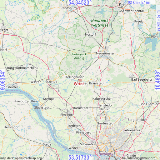
Wrist GPS coordinates[2]
53° 55' 59.988" North, 9° 46' 0.012" East
| Map corner | latitude | longitude |
|---|---|---|
| Upper-left | 54.34523°, | 9.06354° |
| Center: | 53.93333°, | 9.76667° |
| Lower-right: | 53.51733°, | 10.4698° |
| Map W x H: | 92.1×92.1 km | = 57.2×57.2mi |
| max Lat: | 55.01917° ⇑8.2% North |
| Wrist: | 53.93333° |
| min Lat: | ⇓91.8% South 47.40724° |
| min Long | Wrist | max Long |
| 5.92978° | 9.76667° | 14.98853° |
| W 46.6%⇐ | ⇒53.4% E |
Elevation
Elevation of Wrist is 4 m = 13 ft, and this is 245.1 m = 804 ft below average elevation for this country.
| Max E: |
1256 m = 4121 ft | 97% |
| Avg. | 249.1 m = 817 ft | |
| Wrist | 4 m = 13 ft | |
Min E: |
-5 m = -16 ft | 3% |
See also: Germany elevation on elevation.city.
Geographical zone
Wrist is located in North temperate zone (between Tropic of Cancer and the Arctic Circle). Distance of this North polar circle is 1404.3 km =872.6 mi to North.| Distance of | km | miles | from Wrist |
|---|---|---|---|
| North Pole | 4010.2 | 2491.8 | to North |
| Arctic Circle | 1404.3 | 872.6 | to North |
| Tropic Cancer | 3390.9 | 2107 | to South |
| Equator | 5996.8 | 3726.2 | to South |


Nearby cities:
15 places around Wrist: (largest is in red/bold)
• Auufer
5.6 km =3.5 mi,  259°
259°
• Borstel
4.4 km =2.7 mi,  29°
29°
• Brokstedt
6.5 km =4 mi, 30°
• Föhrden-Barl
1.5 km =0.9 mi,  113°
113°
• Hagen
4.2 km =2.6 mi,  69°
69°
• Hingstheide
3.9 km =2.4 mi,  196°
196°
• Hitzhusen
5.7 km =3.5 mi,  100°
100°
• Kellinghusen
3.7 km =2.3 mi,  303°
303°
• Mönkloh
5 km =3.1 mi,  163°
163°
• Quarnstedt
2.7 km =1.7 mi, 29°
• Rosdorf
5.6 km =3.5 mi,  332°
332°
• Störkathen
5.7 km =3.5 mi,  348°
348°
• Weddelbrook
5.7 km =3.5 mi,  130°
130°
• Wittenbergen
5.3 km =3.3 mi,  270°
270°
• Wulfsmoor
3.6 km =2.2 mi,  230°
230°
Sources, notices
• [Note1] Compared only with cities in Germany existing in our database
• [Src1] Map data: © OpenStreetMap contributors (CC-BY-SA)
• [Src2] Other city data from geonames.org with taken over terms of usage.
• [Src3] Geographical zone / Annual Mean Temperature by Robert A. Rohde @ Wikipedia
