Hagen geodata
Hagen (Schleswig-Holstein) is a seat of a fourth-order administrative division; located in Germany in Europe/Berlin (GMT+2) time zone. With population of 381 people, there are 9750 cities with bigger population in this country. Compared to other cities in Germany, 92% of cities are located further ↓South; 52.4% of cities are located further →East and 88.9% of cities have higher elevation than Hagen. Note1


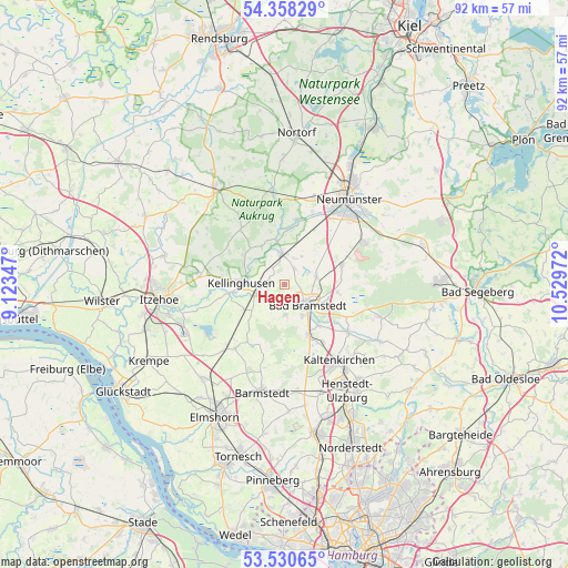
Hagen GPS coordinates[2]
53° 56' 47.472" North, 9° 49' 35.724" East
| Map corner | latitude | longitude |
|---|---|---|
| Upper-left | 54.35829°, | 9.12347° |
| Center: | 53.94652°, | 9.82659° |
| Lower-right: | 53.53065°, | 10.52972° |
| Map W x H: | 92×92 km | = 57.2×57.2mi |
| max Lat: | 55.01917° ⇑8% North |
| Hagen: | 53.94652° |
| min Lat: | ⇓92% South 47.40724° |
| min Long | Hagen | max Long |
| 5.92978° | 9.82659° | 14.98853° |
| W 47.6%⇐ | ⇒52.4% E |
Elevation
Elevation of Hagen is 24 m = 79 ft, and this is 225.1 m = 739 ft below average elevation for this country.
| Max E: |
1256 m = 4121 ft | 88.9% |
| Avg. | 249.1 m = 817 ft | |
| Hagen | 24 m = 79 ft | |
Min E: |
-5 m = -16 ft | 11.1% |
See also: Germany elevation on elevation.city.
Geographical zone
Hagen is located in North temperate zone (between Tropic of Cancer and the Arctic Circle). Distance of this North polar circle is 1402.9 km =871.7 mi to North.| Distance of | km | miles | from Hagen |
|---|---|---|---|
| North Pole | 4008.8 | 2491 | to North |
| Arctic Circle | 1402.9 | 871.7 | to North |
| Tropic Cancer | 3392.4 | 2107.9 | to South |
| Equator | 5998.3 | 3727.2 | to South |


Nearby cities:
15 places around Hagen: (largest is in red/bold)
• Armstedt
3.1 km =1.9 mi,  25°
25°
• Bad Bramstedt
4.9 km =3 mi,  129°
129°
• Borstel
2.9 km =1.8 mi,  322°
322°
• Brokstedt
4.1 km =2.5 mi,  350°
350°
• Fuhlendorf
4 km =2.5 mi,  94°
94°
• Föhrden-Barl
3.3 km =2.1 mi,  231°
231°
• Hardebek
5.4 km =3.4 mi, 30°
• Hasenkrug
4.4 km =2.7 mi,  20°
20°
• Hitzhusen
3 km =1.9 mi,  145°
145°
• Mönkloh
6.8 km =4.2 mi,  202°
202°
• Quarnstedt
2.7 km =1.7 mi,  289°
289°
• Störkathen
6.5 km =4 mi,  309°
309°
• Weddelbrook
5.2 km =3.2 mi,  175°
175°
• Wiemersdorf
5.2 km =3.2 mi,  75°
75°
• Wrist
4.2 km =2.6 mi,  249°
249°
Sources, notices
• [Note1] Compared only with cities in Germany existing in our database
• [Src1] Map data: © OpenStreetMap contributors (CC-BY-SA)
• [Src2] Other city data from geonames.org with taken over terms of usage.
• [Src3] Geographical zone / Annual Mean Temperature by Robert A. Rohde @ Wikipedia
