Weddelbrook geodata
Weddelbrook (Schleswig-Holstein) is a seat of a fourth-order administrative division; located in Germany in Europe/Berlin (GMT+2) time zone. With population of 1,025 people, there are 7091 cities with bigger population in this country. Compared to other cities in Germany, 91.2% of cities are located further ↓South; 52.4% of cities are located further →East and 90.9% of cities have higher elevation than Weddelbrook. Note1
Administrative division(s):
- Level 1: Schleswig-Holstein
- Level 3: Kreis Segeberg
- Level 4: Weddelbrook


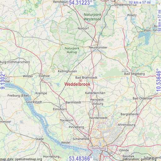
Weddelbrook GPS coordinates[2]
53° 54' 0" North, 9° 49' 59.988" East
| Map corner | latitude | longitude |
|---|---|---|
| Upper-left | 54.31223°, | 9.1302° |
| Center: | 53.9°, | 9.83333° |
| Lower-right: | 53.48366°, | 10.53646° |
| Map W x H: | 92.1×92.1 km | = 57.2×57.2mi |
| max Lat: | 55.01917° ⇑8.8% North |
| Weddelbrook: | 53.9° |
| min Lat: | ⇓91.2% South 47.40724° |
| min Long | Weddelbrook | max Long |
| 5.92978° | 9.83333° | 14.98853° |
| W 47.6%⇐ | ⇒52.4% E |
Elevation
Elevation of Weddelbrook is 19 m = 62 ft, and this is 230.1 m = 755 ft below average elevation for this country.
| Max E: |
1256 m = 4121 ft | 90.9% |
| Avg. | 249.1 m = 817 ft | |
| Weddelbrook | 19 m = 62 ft | |
Min E: |
-5 m = -16 ft | 9.1% |
See also: Germany elevation on elevation.city.
Geographical zone
Weddelbrook is located in North temperate zone (between Tropic of Cancer and the Arctic Circle). Distance of this North polar circle is 1408.1 km =875 mi to North.| Distance of | km | miles | from Weddelbrook |
|---|---|---|---|
| North Pole | 4013.9 | 2494.1 | to North |
| Arctic Circle | 1408.1 | 875 | to North |
| Tropic Cancer | 3387.2 | 2104.7 | to South |
| Equator | 5993.1 | 3723.9 | to South |


Nearby cities:
15 places around Weddelbrook: (largest is in red/bold)
• Bad Bramstedt
3.9 km =2.4 mi,  58°
58°
• Bokel
7.5 km =4.7 mi,  240°
240°
• Borstel
7.8 km =4.8 mi,  343°
343°
• Fuhlendorf
6 km =3.7 mi,  35°
35°
• Föhrden-Barl
4.3 km =2.7 mi,  315°
315°
• Hagen
5.2 km =3.2 mi,  355°
355°
• Heidmoor
7.5 km =4.7 mi,  171°
171°
• Hingstheide
5.5 km =3.4 mi,  270°
270°
• Hitzhusen
2.9 km =1.8 mi,  25°
25°
• Lentföhrden
4.9 km =3 mi,  138°
138°
• Mönkloh
3.2 km =2 mi,  250°
250°
• Nützen
6.6 km =4.1 mi,  124°
124°
• Quarnstedt
6.8 km =4.2 mi,  333°
333°
• Wrist
5.7 km =3.5 mi,  310°
310°
• Wulfsmoor
7.3 km =4.5 mi,  280°
280°
Sources, notices
• [Note1] Compared only with cities in Germany existing in our database
• [Src1] Map data: © OpenStreetMap contributors (CC-BY-SA)
• [Src2] Other city data from geonames.org with taken over terms of usage.
• [Src3] Geographical zone / Annual Mean Temperature by Robert A. Rohde @ Wikipedia
