Colbitz geodata
Colbitz (Saxony-Anhalt) is a seat of a fourth-order administrative division; located in Germany in Europe/Berlin (GMT+2) time zone. With population of 3,443 people, there are 3662 cities with bigger population in this country. Compared to other cities in Germany, 75.4% of cities are located further ↓South; 75.9% of cities are located further ←West and 76.4% of cities have higher elevation than Colbitz. Note1


Colbitz GPS coordinates[2]
52° 19' 1.488" North, 11° 36' 19.224" East
| Map corner | latitude | longitude |
|---|---|---|
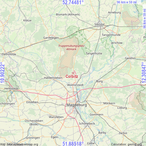
| Upper-left | 52.74481°, | 10.90222° |
| Center: | 52.31708°, | 11.60534° |
| Lower-right: | 51.88518°, | 12.30847° |
| Map W x H: | 95.6×95.6 km | = 59.4×59.4mi |
| max Lat: | 55.01917° ⇑24.6% North |
| Colbitz: | 52.31708° |
| min Lat: | ⇓75.4% South 47.40724° |
| min Long | Colbitz | max Long |
| 5.92978° | 11.60534° | 14.98853° |
| W 75.9%⇐ | ⇒24.1% E |
Elevation
Elevation of Colbitz is 58 m = 190 ft, and this is 191.1 m = 627 ft below average elevation for this country.
| Max E: |
1256 m = 4121 ft | 76.4% |
| Avg. | 249.1 m = 817 ft | |
| Colbitz | 58 m = 190 ft | |
Min E: |
-5 m = -16 ft | 23.6% |
See also: Germany elevation on elevation.city.
Geographical zone
Colbitz is located in North temperate zone (between Tropic of Cancer and the Arctic Circle). Distance of this North polar circle is 1584.1 km =984.3 mi to North.| Distance of | km | miles | from Colbitz |
|---|---|---|---|
| North Pole | 4189.9 | 2603.5 | to North |
| Arctic Circle | 1584.1 | 984.3 | to North |
| Tropic Cancer | 3211.2 | 1995.3 | to South |
| Equator | 5817.1 | 3614.6 | to South |


Nearby cities:
15 places around Colbitz: (largest is in red/bold)
• Angern
9.4 km =5.8 mi,  67°
67°
• Burgstall
11.9 km =7.4 mi,  31°
31°
• Dolle
10.3 km =6.4 mi,  7°
7°
• Farsleben
5.4 km =3.4 mi,  143°
143°
• Glindenberg
10.2 km =6.3 mi,  148°
148°
• Groß Ammensleben
11 km =6.8 mi,  211°
211°
• Hillersleben
9.5 km =5.9 mi,  245°
245°
• Jersleben
8.3 km =5.2 mi,  192°
192°
• Loitsche
6.8 km =4.2 mi,  107°
107°
• Neuenhofe
9.8 km =6.1 mi,  260°
260°
• Rogätz
11 km =6.8 mi,  90°
90°
• Samswegen
6.9 km =4.3 mi, 205°
• Vahldorf
9.9 km =6.2 mi,  227°
227°
• Wolmirstedt
7.8 km =4.8 mi,  167°
167°
• Zielitz
5.7 km =3.5 mi,  122°
122°
Sources, notices
• [Note1] Compared only with cities in Germany existing in our database
• [Src1] Map data: © OpenStreetMap contributors (CC-BY-SA)
• [Src2] Other city data from geonames.org with taken over terms of usage.
• [Src3] Geographical zone / Annual Mean Temperature by Robert A. Rohde @ Wikipedia
