Wolferstadt geodata
Wolferstadt (Bavaria) is a seat of a fourth-order administrative division; located in Germany in Europe/Berlin (GMT+2) time zone. With population of 1,113 people, there are 6815 cities with bigger population in this country. Compared to other cities in Germany, 84% of cities are located further ↑North; 63.7% of cities are located further ←West and 87.7% of cities have lower elevation than Wolferstadt. Note1
Administrative division(s):
- Level 1: Bavaria
- Level 2: Swabia
- Level 3: Landkreis Donau-Ries
- Level 4: Wolferstadt


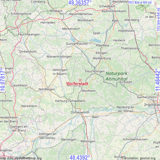
Wolferstadt GPS coordinates[2]
48° 54' 12.672" North, 10° 46' 52.644" East
| Map corner | latitude | longitude |
|---|---|---|
| Upper-left | 49.36357°, | 10.07817° |
| Center: | 48.90352°, | 10.78129° |
| Lower-right: | 48.4392°, | 11.48442° |
| Map W x H: | 102.8×102.8 km | = 63.9×63.9mi |
| max Lat: | 55.01917° ⇑84% North |
| Wolferstadt: | 48.90352° |
| min Lat: | ⇓16% South 47.40724° |
| min Long | Wolferstadt | max Long |
| 5.92978° | 10.78129° | 14.98853° |
| W 63.7%⇐ | ⇒36.3% E |
Elevation
Elevation of Wolferstadt is 491 m = 1611 ft, and this is 241.9 m = 794 ft above average elevation for this country.
| Max E: |
1256 m = 4121 ft | 12.3% |
| Wolferstadt | 491 m 1611 ft | |
| Avg. | 249.1 m = 817 ft | |
Min E: |
-5 m = -16 ft | 87.7% |
See also: Germany elevation on elevation.city.
Geographical zone
Wolferstadt is located in North temperate zone (between Tropic of Cancer and the Arctic Circle). Distance of this North polar circle is 1963.6 km =1220.1 mi to North.| Distance of | km | miles | from Wolferstadt |
|---|---|---|---|
| North Pole | 4569.5 | 2839.4 | to North |
| Arctic Circle | 1963.6 | 1220.1 | to North |
| Tropic Cancer | 2831.6 | 1759.5 | to South |
| Equator | 5437.6 | 3378.8 | to South |


Nearby cities:
15 places around Wolferstadt: (largest is in red/bold)
• Alerheim
13.4 km =8.3 mi,  243°
243°
• Fünfstetten
8 km =5 mi,  188°
188°
• Hainsfarth
13 km =8.1 mi,  298°
298°
• Heidenheim
12.9 km =8 mi,  347°
347°
• Huisheim
10.4 km =6.5 mi,  213°
213°
• Langenaltheim
11 km =6.8 mi,  95°
95°
• Markt Berolzheim
12.7 km =7.9 mi,  21°
21°
• Megesheim
10.1 km =6.3 mi,  289°
289°
• Monheim
8.7 km =5.4 mi,  139°
139°
• Munningen
13.3 km =8.3 mi,  276°
276°
• Otting
3.7 km =2.3 mi,  158°
158°
• Polsingen
5.4 km =3.4 mi, 290°
• Treuchtlingen
10.9 km =6.8 mi,  58°
58°
• Wechingen
12.3 km =7.6 mi,  264°
264°
• Wemding
5.2 km =3.2 mi,  232°
232°
Sources, notices
• [Note1] Compared only with cities in Germany existing in our database
• [Src1] Map data: © OpenStreetMap contributors (CC-BY-SA)
• [Src2] Other city data from geonames.org with taken over terms of usage.
• [Src3] Geographical zone / Annual Mean Temperature by Robert A. Rohde @ Wikipedia
