Treuchtlingen geodata
Treuchtlingen (Bavaria) is a populated place; located in Germany in Europe/Berlin (GMT+2) time zone. With population of 13,141 people, there are 1222 cities with bigger population in this country. Compared to other cities in Germany, 83.4% of cities are located further ↑North; 65.6% of cities are located further ←West and 78.2% of cities have lower elevation than Treuchtlingen. Note1
Administrative division(s):
- Level 1: Bavaria
- Level 2: Regierungsbezirk Mittelfranken
- Level 3: Landkreis Weißenburg-Gunzenhausen
- Level 4: Treuchtlingen


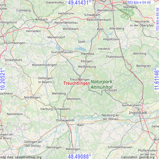
Treuchtlingen GPS coordinates[2]
48° 57' 17.028" North, 10° 54' 29.988" East
| Map corner | latitude | longitude |
|---|---|---|
| Upper-left | 49.41431°, | 10.20521° |
| Center: | 48.95473°, | 10.90833° |
| Lower-right: | 48.49088°, | 11.61146° |
| Map W x H: | 102.7×102.7 km | = 63.8×63.8mi |
| max Lat: | 55.01917° ⇑83.4% North |
| Treuchtlingen: | 48.95473° |
| min Lat: | ⇓16.6% South 47.40724° |
| min Long | Treuchtlingen | max Long |
| 5.92978° | 10.90833° | 14.98853° |
| W 65.6%⇐ | ⇒34.4% E |
Elevation
Elevation of Treuchtlingen is 420 m = 1378 ft, and this is 170.9 m = 561 ft above average elevation for this country.
| Max E: |
1256 m = 4121 ft | 21.8% |
| Treuchtlingen | 420 m 1378 ft | |
| Avg. | 249.1 m = 817 ft | |
Min E: |
-5 m = -16 ft | 78.2% |
See also: Germany elevation on elevation.city.
Geographical zone
Treuchtlingen is located in North temperate zone (between Tropic of Cancer and the Arctic Circle). Distance of this North polar circle is 1957.9 km =1216.6 mi to North.| Distance of | km | miles | from Treuchtlingen |
|---|---|---|---|
| North Pole | 4563.8 | 2835.8 | to North |
| Arctic Circle | 1957.9 | 1216.6 | to North |
| Tropic Cancer | 2837.3 | 1763 | to South |
| Equator | 5443.3 | 3382.3 | to South |


Nearby cities:
15 places around Treuchtlingen: (largest is in red/bold)
• Alesheim
10.7 km =6.6 mi,  342°
342°
• Dittenheim
14 km =8.7 mi,  322°
322°
• Ellingen
12.6 km =7.8 mi,  20°
20°
• Heidenheim
13.9 km =8.6 mi,  299°
299°
• Höttingen
13.9 km =8.6 mi,  30°
30°
• Langenaltheim
7 km =4.3 mi,  166°
166°
• Markt Berolzheim
7.7 km =4.8 mi, 322°
• Meinheim
11 km =6.8 mi, 322°
• Monheim
12.9 km =8 mi,  196°
196°
• Otting
12.1 km =7.5 mi,  220°
220°
• Pappenheim
5.3 km =3.3 mi,  115°
115°
• Rögling
12 km =7.5 mi, 165°
• Solnhofen
9.1 km =5.7 mi,  135°
135°
• Weißenburg in Bayern
9.7 km =6 mi, 28°
• Wolferstadt
10.9 km =6.8 mi,  238°
238°
Sources, notices
• [Note1] Compared only with cities in Germany existing in our database
• [Src1] Map data: © OpenStreetMap contributors (CC-BY-SA)
• [Src2] Other city data from geonames.org with taken over terms of usage.
• [Src3] Geographical zone / Annual Mean Temperature by Robert A. Rohde @ Wikipedia
