Langenaltheim geodata
Langenaltheim (Bavaria) is a seat of a fourth-order administrative division; located in Germany in Europe/Berlin (GMT+2) time zone. With population of 2,450 people, there are 4503 cities with bigger population in this country. Compared to other cities in Germany, 84.1% of cities are located further ↑North; 66% of cities are located further ←West and 92.8% of cities have lower elevation than Langenaltheim. Note1
Administrative division(s):
- Level 1: Bavaria
- Level 2: Regierungsbezirk Mittelfranken
- Level 3: Landkreis Weißenburg-Gunzenhausen
- Level 4: Langenaltheim


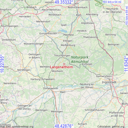
Langenaltheim GPS coordinates[2]
48° 53' 35.448" North, 10° 55' 51.852" East
| Map corner | latitude | longitude |
|---|---|---|
| Upper-left | 49.35332°, | 10.22795° |
| Center: | 48.89318°, | 10.93107° |
| Lower-right: | 48.42876°, | 11.6342° |
| Map W x H: | 102.8×102.8 km | = 63.9×63.9mi |
| max Lat: | 55.01917° ⇑84.1% North |
| Langenaltheim: | 48.89318° |
| min Lat: | ⇓15.9% South 47.40724° |
| min Long | Langenaltheim | max Long |
| 5.92978° | 10.93107° | 14.98853° |
| W 66%⇐ | ⇒34% E |
Elevation
Elevation of Langenaltheim is 555 m = 1821 ft, and this is 305.9 m = 1004 ft above average elevation for this country.
| Max E: |
1256 m = 4121 ft | 7.2% |
| Langenaltheim | 555 m 1821 ft | |
| Avg. | 249.1 m = 817 ft | |
Min E: |
-5 m = -16 ft | 92.8% |
See also: Germany elevation on elevation.city.
Geographical zone
Langenaltheim is located in North temperate zone (between Tropic of Cancer and the Arctic Circle). Distance of this North polar circle is 1964.8 km =1220.9 mi to North.| Distance of | km | miles | from Langenaltheim |
|---|---|---|---|
| North Pole | 4570.6 | 2840 | to North |
| Arctic Circle | 1964.8 | 1220.9 | to North |
| Tropic Cancer | 2830.5 | 1758.8 | to South |
| Equator | 5436.4 | 3378 | to South |


Nearby cities:
15 places around Langenaltheim: (largest is in red/bold)
• Buchdorf
14.2 km =8.8 mi,  210°
210°
• Daiting
11.4 km =7.1 mi,  189°
189°
• Fünfstetten
13.9 km =8.6 mi,  240°
240°
• Markt Berolzheim
14.4 km =8.9 mi,  334°
334°
• Monheim
7.6 km =4.7 mi,  224°
224°
• Otting
9.8 km =6.1 mi,  256°
256°
• Pappenheim
5.5 km =3.4 mi,  34°
34°
• Rögling
5 km =3.1 mi,  163°
163°
• Schernfeld
12.4 km =7.7 mi,  86°
86°
• Solnhofen
4.7 km =2.9 mi, 86°
• Tagmersheim
8.9 km =5.5 mi, 162°
• Treuchtlingen
7 km =4.3 mi,  346°
346°
• Weißenburg in Bayern
15.6 km =9.7 mi,  11°
11°
• Wemding
15.2 km =9.4 mi, 262°
• Wolferstadt
11 km =6.8 mi,  275°
275°
Sources, notices
• [Note1] Compared only with cities in Germany existing in our database
• [Src1] Map data: © OpenStreetMap contributors (CC-BY-SA)
• [Src2] Other city data from geonames.org with taken over terms of usage.
• [Src3] Geographical zone / Annual Mean Temperature by Robert A. Rohde @ Wikipedia
