Monheim geodata
Monheim (Bavaria) is a populated place; located in Germany in Europe/Berlin (GMT+2) time zone. With population of 4,950 people, there are 2848 cities with bigger population in this country. Compared to other cities in Germany, 84.8% of cities are located further ↑North; 64.9% of cities are located further ←West and 88.3% of cities have lower elevation than Monheim. Note1
Administrative division(s):
- Level 1: Bavaria
- Level 2: Swabia
- Level 3: Landkreis Donau-Ries
- Level 4: Monheim


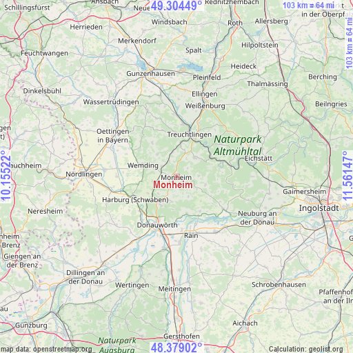
Monheim GPS coordinates[2]
48° 50' 38.004" North, 10° 51' 30.024" East
| Map corner | latitude | longitude |
|---|---|---|
| Upper-left | 49.30449°, | 10.15522° |
| Center: | 48.84389°, | 10.85834° |
| Lower-right: | 48.37902°, | 11.56147° |
| Map W x H: | 102.9×102.9 km | = 63.9×63.9mi |
| max Lat: | 55.01917° ⇑84.8% North |
| Monheim: | 48.84389° |
| min Lat: | ⇓15.2% South 47.40724° |
| min Long | Monheim | max Long |
| 5.92978° | 10.85834° | 14.98853° |
| W 64.9%⇐ | ⇒35.1% E |
Elevation
Elevation of Monheim is 497 m = 1631 ft, and this is 247.9 m = 813 ft above average elevation for this country.
| Max E: |
1256 m = 4121 ft | 11.7% |
| Monheim | 497 m 1631 ft | |
| Avg. | 249.1 m = 817 ft | |
Min E: |
-5 m = -16 ft | 88.3% |
See also: Germany elevation on elevation.city.
Geographical zone
Monheim is located in North temperate zone (between Tropic of Cancer and the Arctic Circle). Distance of this North polar circle is 1970.2 km =1224.2 mi to North.| Distance of | km | miles | from Monheim |
|---|---|---|---|
| North Pole | 4576.1 | 2843.5 | to North |
| Arctic Circle | 1970.2 | 1224.2 | to North |
| Tropic Cancer | 2825 | 1755.4 | to South |
| Equator | 5430.9 | 3374.6 | to South |


Nearby cities:
15 places around Monheim: (largest is in red/bold)
• Buchdorf
7 km =4.3 mi,  195°
195°
• Daiting
6.7 km =4.2 mi,  149°
149°
• Fünfstetten
6.9 km =4.3 mi,  259°
259°
• Huisheim
11.5 km =7.1 mi, 259°
• Kaisheim
9.6 km =6 mi,  208°
208°
• Langenaltheim
7.6 km =4.7 mi,  44°
44°
• Marxheim
13 km =8.1 mi, 150°
• Otting
5.3 km =3.3 mi,  306°
306°
• Pappenheim
13.1 km =8.1 mi, 40°
• Rögling
6.7 km =4.2 mi,  84°
84°
• Solnhofen
11.6 km =7.2 mi,  60°
60°
• Tagmersheim
8.5 km =5.3 mi,  110°
110°
• Treuchtlingen
12.9 km =8 mi,  16°
16°
• Wemding
10.4 km =6.5 mi,  289°
289°
• Wolferstadt
8.7 km =5.4 mi,  319°
319°
Sources, notices
• [Note1] Compared only with cities in Germany existing in our database
• [Src1] Map data: © OpenStreetMap contributors (CC-BY-SA)
• [Src2] Other city data from geonames.org with taken over terms of usage.
• [Src3] Geographical zone / Annual Mean Temperature by Robert A. Rohde @ Wikipedia
