Wittstock geodata
Wittstock (Brandenburg) is a populated place; located in Germany in Europe/Berlin (GMT+2) time zone. With population of 17,361 people, there are 918 cities with bigger population in this country. Compared to other cities in Germany, 82.6% of cities are located further ↓South; 87.8% of cities are located further ←West and 74.3% of cities have higher elevation than Wittstock. Note1
Administrative division(s):
- Level 1: Brandenburg
- Level 3: Landkreis Ostprignitz-Ruppin
- Level 4: Wittstock/Dosse


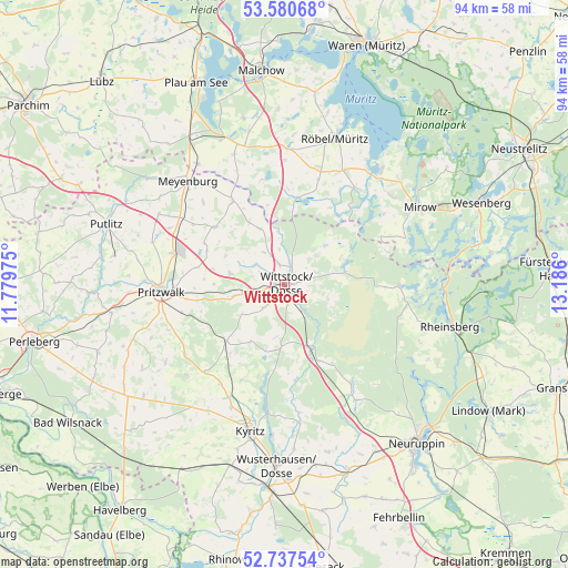
Wittstock GPS coordinates[2]
53° 9' 40.248" North, 12° 28' 58.332" East
| Map corner | latitude | longitude |
|---|---|---|
| Upper-left | 53.58068°, | 11.77975° |
| Center: | 53.16118°, | 12.48287° |
| Lower-right: | 52.73754°, | 13.186° |
| Map W x H: | 93.7×93.7 km | = 58.2×58.2mi |
| max Lat: | 55.01917° ⇑17.4% North |
| Wittstock: | 53.16118° |
| min Lat: | ⇓82.6% South 47.40724° |
| min Long | Wittstock | max Long |
| 5.92978° | 12.48287° | 14.98853° |
| W 87.8%⇐ | ⇒12.2% E |
Elevation
Elevation of Wittstock is 66 m = 217 ft, and this is 183.1 m = 601 ft below average elevation for this country.
| Max E: |
1256 m = 4121 ft | 74.3% |
| Avg. | 249.1 m = 817 ft | |
| Wittstock | 66 m = 217 ft | |
Min E: |
-5 m = -16 ft | 25.7% |
See also: Germany elevation on elevation.city.
Geographical zone
Wittstock is located in North temperate zone (between Tropic of Cancer and the Arctic Circle). Distance of this North polar circle is 1490.2 km =926 mi to North.| Distance of | km | miles | from Wittstock |
|---|---|---|---|
| North Pole | 4096.1 | 2545.2 | to North |
| Arctic Circle | 1490.2 | 926 | to North |
| Tropic Cancer | 3305.1 | 2053.7 | to South |
| Equator | 5911 | 3672.9 | to South |


Nearby cities:
15 places around Wittstock: (largest is in red/bold)
• Bütow
20.5 km =12.7 mi,  0°
0°
• Ganzlin
29.2 km =18.1 mi,  327°
327°
• Gerdshagen
21.1 km =13.1 mi,  296°
296°
• Groß Pankow
29.3 km =18.2 mi,  260°
260°
• Gumtow
25.2 km =15.7 mi,  218°
218°
• Heiligengrabe
8.2 km =5.1 mi, 257°
• Kyritz
25 km =15.5 mi,  193°
193°
• Lärz
22.9 km =14.2 mi,  50°
50°
• Pritzwalk
20.6 km =12.8 mi,  266°
266°
• Rechlin
25.2 km =15.7 mi,  39°
39°
• Rheinsberg
28.6 km =17.8 mi,  103°
103°
• Röbel
25.2 km =15.7 mi,  18°
18°
• Triglitz
26.2 km =16.3 mi,  283°
283°
• Walsleben
27.6 km =17.1 mi,  153°
153°
• Wredenhagen
14.5 km =9 mi,  9°
9°
Sources, notices
• [Note1] Compared only with cities in Germany existing in our database
• [Src1] Map data: © OpenStreetMap contributors (CC-BY-SA)
• [Src2] Other city data from geonames.org with taken over terms of usage.
• [Src3] Geographical zone / Annual Mean Temperature by Robert A. Rohde @ Wikipedia
