Rechlin geodata
Rechlin (Mecklenburg-Vorpommern) is a populated place; located in Germany in Europe/Berlin (GMT+2) time zone. With population of 2,357 people, there are 4597 cities with bigger population in this country. Compared to other cities in Germany, 84% of cities are located further ↓South; 90.1% of cities are located further ←West and 74.1% of cities have higher elevation than Rechlin. Note1
Administrative division(s):
- Level 1: Mecklenburg-Vorpommern
- Level 3: Mecklenburgische Seenplatte
- Level 4: Rechlin


Rechlin GPS coordinates[2]
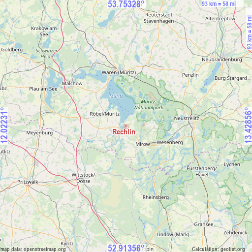
53° 20' 7.764" North, 12° 43' 31.548" East
| Map corner | latitude | longitude |
|---|---|---|
| Upper-left | 53.75328°, | 12.02231° |
| Center: | 53.33549°, | 12.72543° |
| Lower-right: | 52.91356°, | 13.42856° |
| Map W x H: | 93.4×93.4 km | = 58×58mi |
| max Lat: | 55.01917° ⇑16% North |
| Rechlin: | 53.33549° |
| min Lat: | ⇓84% South 47.40724° |
| min Long | Rechlin | max Long |
| 5.92978° | 12.72543° | 14.98853° |
| W 90.1%⇐ | ⇒9.9% E |
Elevation
Elevation of Rechlin is 67 m = 220 ft, and this is 182.1 m = 597 ft below average elevation for this country.
| Max E: |
1256 m = 4121 ft | 74.1% |
| Avg. | 249.1 m = 817 ft | |
| Rechlin | 67 m = 220 ft | |
Min E: |
-5 m = -16 ft | 25.9% |
See also: Germany elevation on elevation.city.
Geographical zone
Rechlin is located in North temperate zone (between Tropic of Cancer and the Arctic Circle). Distance of this North polar circle is 1470.8 km =913.9 mi to North.| Distance of | km | miles | from Rechlin |
|---|---|---|---|
| North Pole | 4076.7 | 2533.1 | to North |
| Arctic Circle | 1470.8 | 913.9 | to North |
| Tropic Cancer | 3324.4 | 2065.7 | to South |
| Equator | 5930.4 | 3685 | to South |


Nearby cities:
15 places around Rechlin: (largest is in red/bold)
• Ankershagen
22.7 km =14.1 mi,  44°
44°
• Bütow
16.1 km =10 mi,  273°
273°
• Göhren-Lebbin
21.4 km =13.3 mi,  318°
318°
• Kargow
19.8 km =12.3 mi,  11°
11°
• Klink
17.2 km =10.7 mi,  336°
336°
• Kratzeburg
17.7 km =11 mi,  53°
53°
• Lärz
4.9 km =3 mi,  163°
163°
• Neustrelitz
23.2 km =14.4 mi,  82°
82°
• Roggentin
10.4 km =6.5 mi,  90°
90°
• Röbel
9.2 km =5.7 mi,  298°
298°
• Sietow
16.5 km =10.3 mi, 317°
• Userin
16.9 km =10.5 mi, 88°
• Waren
20.8 km =12.9 mi,  351°
351°
• Wesenberg
17.3 km =10.7 mi,  110°
110°
• Wredenhagen
14.7 km =9.1 mi,  250°
250°
Sources, notices
• [Note1] Compared only with cities in Germany existing in our database
• [Src1] Map data: © OpenStreetMap contributors (CC-BY-SA)
• [Src2] Other city data from geonames.org with taken over terms of usage.
• [Src3] Geographical zone / Annual Mean Temperature by Robert A. Rohde @ Wikipedia
