Ganzlin geodata
Ganzlin (Mecklenburg-Vorpommern) is a populated place; located in Germany in Europe/Berlin (GMT+2) time zone. With population of 598 people, there are 8837 cities with bigger population in this country. Compared to other cities in Germany, 84.3% of cities are located further ↓South; 85.2% of cities are located further ←West and 70.9% of cities have higher elevation than Ganzlin. Note1
Administrative division(s):
- Level 1: Mecklenburg-Vorpommern
- Level 3: Ludwigslust-Parchim
- Level 4: Ganzlin


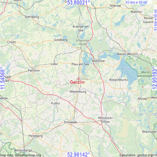
Ganzlin GPS coordinates[2]
53° 22' 58.368" North, 12° 14' 55.68" East
| Map corner | latitude | longitude |
|---|---|---|
| Upper-left | 53.80021°, | 11.54568° |
| Center: | 53.38288°, | 12.2488° |
| Lower-right: | 52.96142°, | 12.95193° |
| Map W x H: | 93.3×93.3 km | = 58×58mi |
| max Lat: | 55.01917° ⇑15.7% North |
| Ganzlin: | 53.38288° |
| min Lat: | ⇓84.3% South 47.40724° |
| min Long | Ganzlin | max Long |
| 5.92978° | 12.2488° | 14.98853° |
| W 85.2%⇐ | ⇒14.8% E |
Elevation
Elevation of Ganzlin is 86 m = 282 ft, and this is 163.1 m = 535 ft below average elevation for this country.
| Max E: |
1256 m = 4121 ft | 70.9% |
| Avg. | 249.1 m = 817 ft | |
| Ganzlin | 86 m = 282 ft | |
Min E: |
-5 m = -16 ft | 29.1% |
See also: Germany elevation on elevation.city.
Geographical zone
Ganzlin is located in North temperate zone (between Tropic of Cancer and the Arctic Circle). Distance of this North polar circle is 1465.6 km =910.7 mi to North.| Distance of | km | miles | from Ganzlin |
|---|---|---|---|
| North Pole | 4071.4 | 2529.8 | to North |
| Arctic Circle | 1465.6 | 910.7 | to North |
| Tropic Cancer | 3329.7 | 2069 | to South |
| Equator | 5935.6 | 3688.2 | to South |


Nearby cities:
15 places around Ganzlin: (largest is in red/bold)
• Alt Schwerin
15.8 km =9.8 mi,  24°
24°
• Bütow
16.2 km =10.1 mi,  104°
104°
• Gallin
16.4 km =10.2 mi,  329°
329°
• Gerdshagen
15.7 km =9.8 mi,  192°
192°
• Göhren-Lebbin
20.4 km =12.7 mi,  58°
58°
• Lübz
17 km =10.6 mi,  301°
301°
• Malchow
15.4 km =9.6 mi,  48°
48°
• Neu Poserin
19.7 km =12.2 mi,  343°
343°
• Nossentiner Hütte
20.5 km =12.7 mi,  34°
34°
• Passow
18.9 km =11.7 mi,  316°
316°
• Plau am See
8.4 km =5.2 mi,  6°
6°
• Putlitz
20.3 km =12.6 mi,  222°
222°
• Siggelkow
20.6 km =12.8 mi,  271°
271°
• Werder
20.7 km =12.9 mi,  309°
309°
• Wredenhagen
20.6 km =12.8 mi,  120°
120°
Sources, notices
• [Note1] Compared only with cities in Germany existing in our database
• [Src1] Map data: © OpenStreetMap contributors (CC-BY-SA)
• [Src2] Other city data from geonames.org with taken over terms of usage.
• [Src3] Geographical zone / Annual Mean Temperature by Robert A. Rohde @ Wikipedia
