Wittgendorf geodata
Wittgendorf (Thuringia) is a seat of a fourth-order administrative division; located in Germany in Europe/Berlin (GMT+2) time zone. With population of 216 people, there are 10403 cities with bigger population in this country. Compared to other cities in Germany, 50.6% of cities are located further ↑North; 70.4% of cities are located further ←West and 93.1% of cities have lower elevation than Wittgendorf. Note1


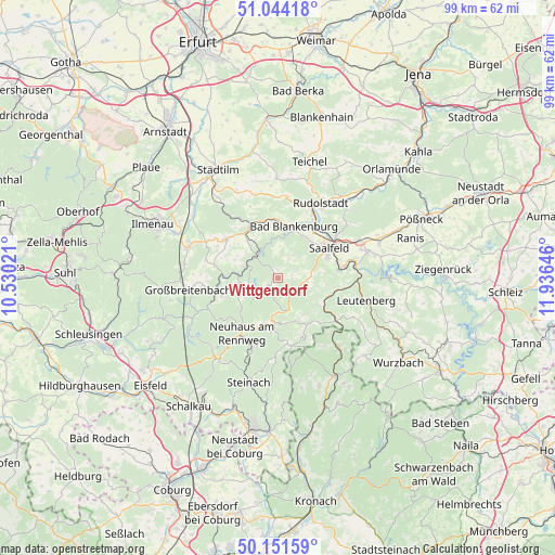
Wittgendorf GPS coordinates[2]
50° 36' 0" North, 11° 13' 59.988" East
| Map corner | latitude | longitude |
|---|---|---|
| Upper-left | 51.04418°, | 10.53021° |
| Center: | 50.6°, | 11.23333° |
| Lower-right: | 50.15159°, | 11.93646° |
| Map W x H: | 99.2×99.2 km | = 61.6×61.6mi |
| max Lat: | 55.01917° ⇑50.6% North |
| Wittgendorf: | 50.6° |
| min Lat: | ⇓49.4% South 47.40724° |
| min Long | Wittgendorf | max Long |
| 5.92978° | 11.23333° | 14.98853° |
| W 70.4%⇐ | ⇒29.6% E |
Elevation
Elevation of Wittgendorf is 559 m = 1834 ft, and this is 309.9 m = 1017 ft above average elevation for this country.
| Max E: |
1256 m = 4121 ft | 6.9% |
| Wittgendorf | 559 m 1834 ft | |
| Avg. | 249.1 m = 817 ft | |
Min E: |
-5 m = -16 ft | 93.1% |
See also: Germany elevation on elevation.city.
Geographical zone
Wittgendorf is located in North temperate zone (between Tropic of Cancer and the Arctic Circle). Distance of this North polar circle is 1775 km =1102.9 mi to North.| Distance of | km | miles | from Wittgendorf |
|---|---|---|---|
| North Pole | 4380.9 | 2722.2 | to North |
| Arctic Circle | 1775 | 1102.9 | to North |
| Tropic Cancer | 3020.3 | 1876.7 | to South |
| Equator | 5626.2 | 3496 | to South |


Nearby cities:
15 places around Wittgendorf: (largest is in red/bold)
• Allendorf
8.1 km =5 mi,  318°
318°
• Bechstedt
8.8 km =5.5 mi,  327°
327°
• Cursdorf
8 km =5 mi,  242°
242°
• Deesbach
7 km =4.3 mi, 237°
• Döschnitz
1.9 km =1.2 mi,  0°
0°
• Marktgölitz
8.7 km =5.4 mi,  124°
124°
• Meura
3 km =1.9 mi,  231°
231°
• Oberhain
8 km =5 mi,  297°
297°
• Oberweißbach
6.6 km =4.1 mi,  252°
252°
• Reichmannsdorf
5.9 km =3.7 mi,  163°
163°
• Rohrbach
1.2 km =0.7 mi,  270°
270°
• Schmiedefeld
7.5 km =4.7 mi,  189°
189°
• Schwarzburg
5.6 km =3.5 mi, 328°
• Sitzendorf
5.6 km =3.5 mi,  309°
309°
• Unterweißbach
4.9 km =3 mi,  288°
288°
Sources, notices
• [Note1] Compared only with cities in Germany existing in our database
• [Src1] Map data: © OpenStreetMap contributors (CC-BY-SA)
• [Src2] Other city data from geonames.org with taken over terms of usage.
• [Src3] Geographical zone / Annual Mean Temperature by Robert A. Rohde @ Wikipedia
