Döschnitz geodata
Döschnitz (Thuringia) is a seat of a fourth-order administrative division; located in Germany in Europe/Berlin (GMT+2) time zone. With population of 310 people, there are 10018 cities with bigger population in this country. Compared to other cities in Germany, 50.2% of cities are located further ↑North; 70.4% of cities are located further ←West and 85.3% of cities have lower elevation than Döschnitz. Note1


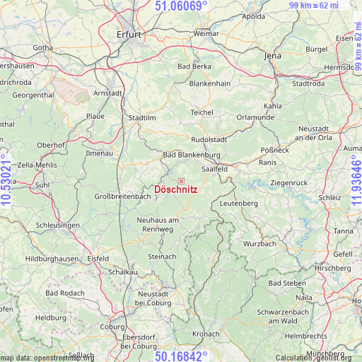
Döschnitz GPS coordinates[2]
50° 37' 0.012" North, 11° 13' 59.988" East
| Map corner | latitude | longitude |
|---|---|---|
| Upper-left | 51.06069°, | 10.53021° |
| Center: | 50.61667°, | 11.23333° |
| Lower-right: | 50.16842°, | 11.93646° |
| Map W x H: | 99.2×99.2 km | = 61.6×61.6mi |
| max Lat: | 55.01917° ⇑50.2% North |
| Döschnitz: | 50.61667° |
| min Lat: | ⇓49.8% South 47.40724° |
| min Long | Döschnitz | max Long |
| 5.92978° | 11.23333° | 14.98853° |
| W 70.4%⇐ | ⇒29.6% E |
Elevation
Elevation of Döschnitz is 472 m = 1549 ft, and this is 222.9 m = 731 ft above average elevation for this country.
| Max E: |
1256 m = 4121 ft | 14.7% |
| Döschnitz | 472 m 1549 ft | |
| Avg. | 249.1 m = 817 ft | |
Min E: |
-5 m = -16 ft | 85.3% |
See also: Germany elevation on elevation.city.
Geographical zone
Döschnitz is located in North temperate zone (between Tropic of Cancer and the Arctic Circle). Distance of this North polar circle is 1773.1 km =1101.8 mi to North.| Distance of | km | miles | from Döschnitz |
|---|---|---|---|
| North Pole | 4379 | 2721 | to North |
| Arctic Circle | 1773.1 | 1101.8 | to North |
| Tropic Cancer | 3022.1 | 1877.8 | to South |
| Equator | 5628 | 3497.1 | to South |


Nearby cities:
15 places around Döschnitz: (largest is in red/bold)
• Allendorf
6.8 km =4.2 mi,  308°
308°
• Bad Blankenburg
7.8 km =4.8 mi,  21°
21°
• Bechstedt
7.3 km =4.5 mi,  319°
319°
• Cursdorf
9 km =5.6 mi,  231°
231°
• Deesbach
8.1 km =5 mi, 226°
• Meura
4.4 km =2.7 mi,  212°
212°
• Oberhain
7.3 km =4.5 mi,  284°
284°
• Oberweißbach
7.4 km =4.6 mi,  238°
238°
• Reichmannsdorf
7.6 km =4.7 mi,  167°
167°
• Rohrbach
2.2 km =1.4 mi, 212°
• Rottenbach
9.2 km =5.7 mi,  329°
329°
• Schwarzburg
4.1 km =2.5 mi, 315°
• Sitzendorf
4.6 km =2.9 mi,  291°
291°
• Unterweißbach
4.7 km =2.9 mi,  266°
266°
• Wittgendorf
1.9 km =1.2 mi,  180°
180°
Sources, notices
• [Note1] Compared only with cities in Germany existing in our database
• [Src1] Map data: © OpenStreetMap contributors (CC-BY-SA)
• [Src2] Other city data from geonames.org with taken over terms of usage.
• [Src3] Geographical zone / Annual Mean Temperature by Robert A. Rohde @ Wikipedia
