Oberweißbach geodata
Oberweißbach (Thuringia) is a populated place; located in Germany in Europe/Berlin (GMT+2) time zone. With population of 1,653 people, there are 5596 cities with bigger population in this country. Compared to other cities in Germany, 51% of cities are located further ↑North; 69.1% of cities are located further ←West and 96.2% of cities have lower elevation than Oberweißbach. Note1
Administrative division(s):
- Level 1: Thuringia
- Level 3: Saalfeld-Rudolstadt
- Level 4: Stadt Schwarzatal


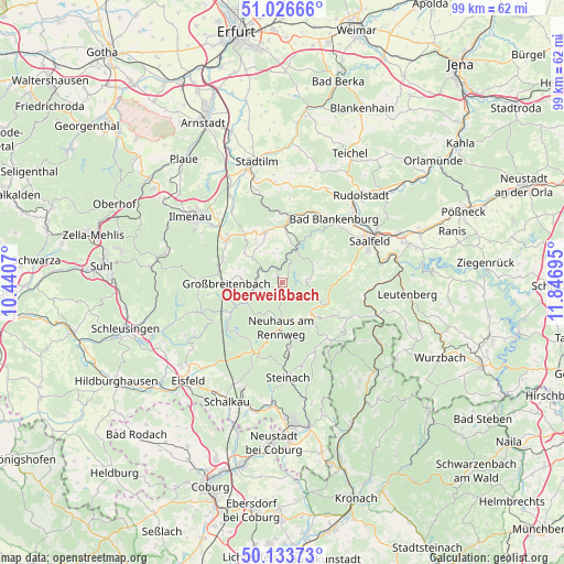
Oberweißbach GPS coordinates[2]
50° 34' 56.316" North, 11° 8' 37.752" East
| Map corner | latitude | longitude |
|---|---|---|
| Upper-left | 51.02666°, | 10.4407° |
| Center: | 50.58231°, | 11.14382° |
| Lower-right: | 50.13373°, | 11.84695° |
| Map W x H: | 99.3×99.3 km | = 61.7×61.7mi |
| max Lat: | 55.01917° ⇑51% North |
| Oberweißbach: | 50.58231° |
| min Lat: | ⇓49% South 47.40724° |
| min Long | Oberweißbach | max Long |
| 5.92978° | 11.14382° | 14.98853° |
| W 69.1%⇐ | ⇒30.9% E |
Elevation
Elevation of Oberweißbach is 634 m = 2080 ft, and this is 384.9 m = 1263 ft above average elevation for this country.
| Max E: |
1256 m = 4121 ft | 3.8% |
| Oberweißbach | 634 m 2080 ft | |
| Avg. | 249.1 m = 817 ft | |
Min E: |
-5 m = -16 ft | 96.2% |
See also: Germany elevation on elevation.city.
Geographical zone
Oberweißbach is located in North temperate zone (between Tropic of Cancer and the Arctic Circle). Distance of this North polar circle is 1776.9 km =1104.1 mi to North.| Distance of | km | miles | from Oberweißbach |
|---|---|---|---|
| North Pole | 4382.8 | 2723.3 | to North |
| Arctic Circle | 1776.9 | 1104.1 | to North |
| Tropic Cancer | 3018.3 | 1875.5 | to South |
| Equator | 5624.2 | 3494.7 | to South |


Nearby cities:
15 places around Oberweißbach: (largest is in red/bold)
• Böhlen
7.1 km =4.4 mi,  275°
275°
• Cursdorf
1.9 km =1.2 mi,  203°
203°
• Deesbach
1.8 km =1.1 mi,  165°
165°
• Dröbischau
7.3 km =4.5 mi,  316°
316°
• Döschnitz
7.4 km =4.6 mi,  58°
58°
• Katzhütte
7.3 km =4.5 mi,  242°
242°
• Mellenbach-Glasbach
4.9 km =3 mi, 321°
• Meura
4 km =2.5 mi,  88°
88°
• Meuselbach
3.9 km =2.4 mi,  252°
252°
• Oberhain
5.7 km =3.5 mi,  352°
352°
• Rohrbach
5.5 km =3.4 mi,  69°
69°
• Sitzendorf
5.9 km =3.7 mi,  19°
19°
• Unterweißbach
3.9 km =2.4 mi,  25°
25°
• Wildenspring
5.8 km =3.6 mi,  289°
289°
• Wittgendorf
6.6 km =4.1 mi, 72°
In other languages:
- In German: Oberweißbach, Oberweißbach/Thüringer Wald
- In Russian: Обервайсбах
- In Chinese: 奥伯韦斯巴赫
Sources, notices
• [Note1] Compared only with cities in Germany existing in our database
• [Src1] Map data: © OpenStreetMap contributors (CC-BY-SA)
• [Src2] Other city data from geonames.org with taken over terms of usage.
• [Src3] Geographical zone / Annual Mean Temperature by Robert A. Rohde @ Wikipedia
