Wirges geodata
Wirges (Rheinland-Pfalz) is a populated place; located in Germany in Europe/Berlin (GMT+2) time zone. With population of 5,201 people, there are 2741 cities with bigger population in this country. Compared to other cities in Germany, 53.3% of cities are located further ↑North; 81% of cities are located further →East and 56.9% of cities have lower elevation than Wirges. Note1


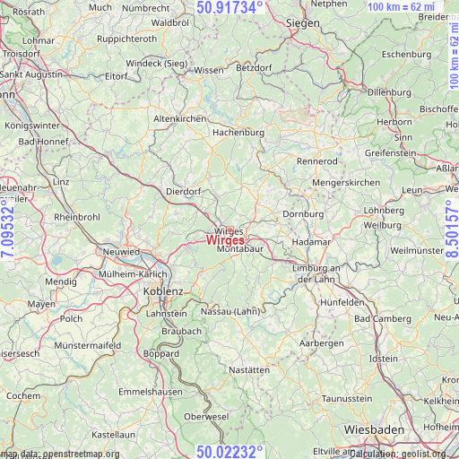
Wirges GPS coordinates[2]
50° 28' 19.02" North, 7° 47' 54.384" East
| Map corner | latitude | longitude |
|---|---|---|
| Upper-left | 50.91734°, | 7.09532° |
| Center: | 50.47195°, | 7.79844° |
| Lower-right: | 50.02232°, | 8.50157° |
| Map W x H: | 99.5×99.5 km | = 61.8×61.8mi |
| max Lat: | 55.01917° ⇑53.3% North |
| Wirges: | 50.47195° |
| min Lat: | ⇓46.7% South 47.40724° |
| min Long | Wirges | max Long |
| 5.92978° | 7.79844° | 14.98853° |
| W 19%⇐ | ⇒81% E |
Elevation
Elevation of Wirges is 271 m = 889 ft, and this is 21.9 m = 72 ft above average elevation for this country.
| Max E: |
1256 m = 4121 ft | 43.1% |
| Wirges | 271 m 889 ft | |
| Avg. | 249.1 m = 817 ft | |
Min E: |
-5 m = -16 ft | 56.9% |
See also: Germany elevation on elevation.city.
Geographical zone
Wirges is located in North temperate zone (between Tropic of Cancer and the Arctic Circle). Distance of this North polar circle is 1789.2 km =1111.8 mi to North.| Distance of | km | miles | from Wirges |
|---|---|---|---|
| North Pole | 4395.1 | 2731 | to North |
| Arctic Circle | 1789.2 | 1111.8 | to North |
| Tropic Cancer | 3006 | 1867.8 | to South |
| Equator | 5612 | 3487.1 | to South |


Nearby cities:
15 places around Wirges: (largest is in red/bold)
• Bannberscheid
2.7 km =1.7 mi,  90°
90°
• Boden
4.1 km =2.5 mi, 86°
• Dernbach
1.9 km =1.2 mi,  198°
198°
• Ebernhahn
2 km =1.2 mi,  272°
272°
• Helferskirchen
4.4 km =2.7 mi,  12°
12°
• Leuterod
3 km =1.9 mi,  28°
28°
• Mogendorf
3.7 km =2.3 mi,  312°
312°
• Montabaur
4.4 km =2.7 mi,  156°
156°
• Moschheim
3.3 km =2.1 mi,  69°
69°
• Niederahr
5 km =3.1 mi,  63°
63°
• Ransbach-Baumbach
5 km =3.1 mi,  261°
261°
• Siershahn
2.1 km =1.3 mi,  320°
320°
• Staudt
2.5 km =1.6 mi,  103°
103°
• Vielbach
4.7 km =2.9 mi,  336°
336°
• Ötzingen
4 km =2.5 mi,  38°
38°
Sources, notices
• [Note1] Compared only with cities in Germany existing in our database
• [Src1] Map data: © OpenStreetMap contributors (CC-BY-SA)
• [Src2] Other city data from geonames.org with taken over terms of usage.
• [Src3] Geographical zone / Annual Mean Temperature by Robert A. Rohde @ Wikipedia
