Siershahn geodata
Siershahn (Rheinland-Pfalz) is a seat of a fourth-order administrative division; located in Germany in Europe/Berlin (GMT+2) time zone. With population of 2,879 people, there are 4117 cities with bigger population in this country. Compared to other cities in Germany, 53% of cities are located further ↑North; 81.4% of cities are located further →East and 62.8% of cities have lower elevation than Siershahn. Note1


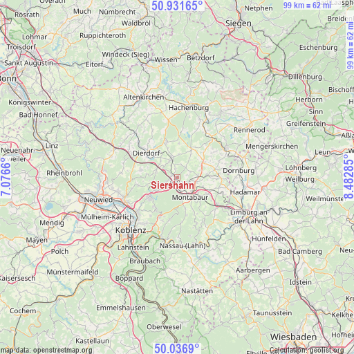
Siershahn GPS coordinates[2]
50° 29' 11.004" North, 7° 46' 46.992" East
| Map corner | latitude | longitude |
|---|---|---|
| Upper-left | 50.93165°, | 7.0766° |
| Center: | 50.48639°, | 7.77972° |
| Lower-right: | 50.0369°, | 8.48285° |
| Map W x H: | 99.5×99.5 km | = 61.8×61.8mi |
| max Lat: | 55.01917° ⇑53% North |
| Siershahn: | 50.48639° |
| min Lat: | ⇓47% South 47.40724° |
| min Long | Siershahn | max Long |
| 5.92978° | 7.77972° | 14.98853° |
| W 18.6%⇐ | ⇒81.4% E |
Elevation
Elevation of Siershahn is 307 m = 1007 ft, and this is 57.9 m = 190 ft above average elevation for this country.
| Max E: |
1256 m = 4121 ft | 37.2% |
| Siershahn | 307 m 1007 ft | |
| Avg. | 249.1 m = 817 ft | |
Min E: |
-5 m = -16 ft | 62.8% |
See also: Germany elevation on elevation.city.
Geographical zone
Siershahn is located in North temperate zone (between Tropic of Cancer and the Arctic Circle). Distance of this North polar circle is 1787.6 km =1110.8 mi to North.| Distance of | km | miles | from Siershahn |
|---|---|---|---|
| North Pole | 4393.5 | 2730 | to North |
| Arctic Circle | 1787.6 | 1110.8 | to North |
| Tropic Cancer | 3007.6 | 1868.8 | to South |
| Equator | 5613.6 | 3488.1 | to South |


Nearby cities:
15 places around Siershahn: (largest is in red/bold)
• Bannberscheid
4.3 km =2.7 mi,  111°
111°
• Dernbach
3.5 km =2.2 mi,  168°
168°
• Ebernhahn
1.7 km =1.1 mi,  204°
204°
• Ellenhausen
5.1 km =3.2 mi,  310°
310°
• Helferskirchen
3.5 km =2.2 mi,  40°
40°
• Leuterod
3 km =1.9 mi,  69°
69°
• Mogendorf
1.7 km =1.1 mi,  302°
302°
• Moschheim
4.4 km =2.7 mi,  95°
95°
• Nordhofen
4 km =2.5 mi,  328°
328°
• Quirnbach
4 km =2.5 mi,  17°
17°
• Ransbach-Baumbach
4.3 km =2.7 mi,  236°
236°
• Staudt
4.4 km =2.7 mi,  120°
120°
• Vielbach
2.7 km =1.7 mi,  348°
348°
• Wirges
2.1 km =1.3 mi,  140°
140°
• Ötzingen
4.1 km =2.5 mi, 68°
Sources, notices
• [Note1] Compared only with cities in Germany existing in our database
• [Src1] Map data: © OpenStreetMap contributors (CC-BY-SA)
• [Src2] Other city data from geonames.org with taken over terms of usage.
• [Src3] Geographical zone / Annual Mean Temperature by Robert A. Rohde @ Wikipedia
