Mogendorf geodata
Mogendorf (Rheinland-Pfalz) is a seat of a fourth-order administrative division; located in Germany in Europe/Berlin (GMT+2) time zone. With population of 1,204 people, there are 6550 cities with bigger population in this country. Compared to other cities in Germany, 52.9% of cities are located further ↑North; 81.9% of cities are located further →East and 58.7% of cities have lower elevation than Mogendorf. Note1


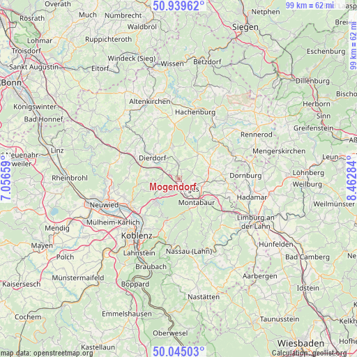
Mogendorf GPS coordinates[2]
50° 29' 39.984" North, 7° 45' 34.992" East
| Map corner | latitude | longitude |
|---|---|---|
| Upper-left | 50.93962°, | 7.05659° |
| Center: | 50.49444°, | 7.75972° |
| Lower-right: | 50.04503°, | 8.46284° |
| Map W x H: | 99.5×99.5 km | = 61.8×61.8mi |
| max Lat: | 55.01917° ⇑52.9% North |
| Mogendorf: | 50.49444° |
| min Lat: | ⇓47.1% South 47.40724° |
| min Long | Mogendorf | max Long |
| 5.92978° | 7.75972° | 14.98853° |
| W 18.1%⇐ | ⇒81.9% E |
Elevation
Elevation of Mogendorf is 282 m = 925 ft, and this is 32.9 m = 108 ft above average elevation for this country.
| Max E: |
1256 m = 4121 ft | 41.3% |
| Mogendorf | 282 m 925 ft | |
| Avg. | 249.1 m = 817 ft | |
Min E: |
-5 m = -16 ft | 58.7% |
See also: Germany elevation on elevation.city.
Geographical zone
Mogendorf is located in North temperate zone (between Tropic of Cancer and the Arctic Circle). Distance of this North polar circle is 1786.7 km =1110.2 mi to North.| Distance of | km | miles | from Mogendorf |
|---|---|---|---|
| North Pole | 4392.6 | 2729.4 | to North |
| Arctic Circle | 1786.7 | 1110.2 | to North |
| Tropic Cancer | 3008.5 | 1869.4 | to South |
| Equator | 5614.5 | 3488.7 | to South |


Nearby cities:
15 places around Mogendorf: (largest is in red/bold)
• Deesen
4.6 km =2.9 mi,  293°
293°
• Dernbach
4.8 km =3 mi,  153°
153°
• Ebernhahn
2.5 km =1.6 mi,  163°
163°
• Ellenhausen
3.4 km =2.1 mi,  315°
315°
• Helferskirchen
4.1 km =2.5 mi,  64°
64°
• Hundsdorf
4.9 km =3 mi,  236°
236°
• Leuterod
4.2 km =2.6 mi,  87°
87°
• Nordhofen
2.6 km =1.6 mi,  344°
344°
• Quirnbach
3.9 km =2.4 mi,  41°
41°
• Ransbach-Baumbach
4 km =2.5 mi,  214°
214°
• Selters
4.2 km =2.6 mi,  356°
356°
• Siershahn
1.7 km =1.1 mi,  122°
122°
• Vielbach
2 km =1.2 mi,  25°
25°
• Wirges
3.7 km =2.3 mi,  132°
132°
• Wittgert
4.3 km =2.7 mi,  278°
278°
Sources, notices
• [Note1] Compared only with cities in Germany existing in our database
• [Src1] Map data: © OpenStreetMap contributors (CC-BY-SA)
• [Src2] Other city data from geonames.org with taken over terms of usage.
• [Src3] Geographical zone / Annual Mean Temperature by Robert A. Rohde @ Wikipedia
