Wilhelmsdorf geodata
Wilhelmsdorf (Thuringia) is a seat of a fourth-order administrative division; located in Germany in Europe/Berlin (GMT+2) time zone. With population of 233 people, there are 10338 cities with bigger population in this country. Compared to other cities in Germany, 50.2% of cities are located further ↓South; 75% of cities are located further ←West and 86.7% of cities have lower elevation than Wilhelmsdorf. Note1


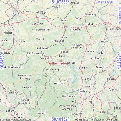
Wilhelmsdorf GPS coordinates[2]
50° 37' 46.74" North, 11° 32' 59.316" East
| Map corner | latitude | longitude |
|---|---|---|
| Upper-left | 51.07355°, | 10.84669° |
| Center: | 50.62965°, | 11.54981° |
| Lower-right: | 50.18152°, | 12.25294° |
| Map W x H: | 99.2×99.2 km | = 61.6×61.6mi |
| max Lat: | 55.01917° ⇑49.8% North |
| Wilhelmsdorf: | 50.62965° |
| min Lat: | ⇓50.2% South 47.40724° |
| min Long | Wilhelmsdorf | max Long |
| 5.92978° | 11.54981° | 14.98853° |
| W 75%⇐ | ⇒25% E |
Elevation
Elevation of Wilhelmsdorf is 483 m = 1585 ft, and this is 233.9 m = 767 ft above average elevation for this country.
| Max E: |
1256 m = 4121 ft | 13.3% |
| Wilhelmsdorf | 483 m 1585 ft | |
| Avg. | 249.1 m = 817 ft | |
Min E: |
-5 m = -16 ft | 86.7% |
See also: Germany elevation on elevation.city.
Geographical zone
Wilhelmsdorf is located in North temperate zone (between Tropic of Cancer and the Arctic Circle). Distance of this North polar circle is 1771.7 km =1100.9 mi to North.| Distance of | km | miles | from Wilhelmsdorf |
|---|---|---|---|
| North Pole | 4377.6 | 2720.1 | to North |
| Arctic Circle | 1771.7 | 1100.9 | to North |
| Tropic Cancer | 3023.6 | 1878.8 | to South |
| Equator | 5629.5 | 3498 | to South |


Nearby cities:
15 places around Wilhelmsdorf: (largest is in red/bold)
• Altenbeuthen
5.5 km =3.4 mi,  139°
139°
• Birkigt
6.4 km =4 mi,  313°
313°
• Drognitz
4.9 km =3 mi,  161°
161°
• Goßwitz
5.1 km =3.2 mi,  277°
277°
• Gössitz
2.7 km =1.7 mi,  108°
108°
• Hohenwarte
5.7 km =3.5 mi,  234°
234°
• Kamsdorf
6.9 km =4.3 mi, 282°
• Krölpa
5.4 km =3.4 mi,  351°
351°
• Könitz
4.9 km =3 mi,  297°
297°
• Moxa
6.3 km =3.9 mi,  68°
68°
• Paska
5.7 km =3.5 mi,  101°
101°
• Ranis
3.8 km =2.4 mi,  21°
21°
• Schmorda
3.1 km =1.9 mi,  56°
56°
• Seisla
2.5 km =1.6 mi,  335°
335°
• Wernburg
6.5 km =4 mi,  34°
34°
Sources, notices
• [Note1] Compared only with cities in Germany existing in our database
• [Src1] Map data: © OpenStreetMap contributors (CC-BY-SA)
• [Src2] Other city data from geonames.org with taken over terms of usage.
• [Src3] Geographical zone / Annual Mean Temperature by Robert A. Rohde @ Wikipedia
