Hohenwarte geodata
Hohenwarte (Thuringia) is a seat of a fourth-order administrative division; located in Germany in Europe/Berlin (GMT+2) time zone. With population of 158 people, there are 10653 cities with bigger population in this country. Compared to other cities in Germany, 50.6% of cities are located further ↑North; 74% of cities are located further ←West and 67.2% of cities have lower elevation than Hohenwarte. Note1


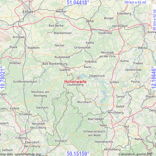
Hohenwarte GPS coordinates[2]
50° 36' 0" North, 11° 28' 59.988" East
| Map corner | latitude | longitude |
|---|---|---|
| Upper-left | 51.04418°, | 10.78021° |
| Center: | 50.6°, | 11.48333° |
| Lower-right: | 50.15159°, | 12.18646° |
| Map W x H: | 99.2×99.2 km | = 61.6×61.6mi |
| max Lat: | 55.01917° ⇑50.6% North |
| Hohenwarte: | 50.6° |
| min Lat: | ⇓49.4% South 47.40724° |
| min Long | Hohenwarte | max Long |
| 5.92978° | 11.48333° | 14.98853° |
| W 74%⇐ | ⇒26% E |
Elevation
Elevation of Hohenwarte is 337 m = 1106 ft, and this is 87.9 m = 288 ft above average elevation for this country.
| Max E: |
1256 m = 4121 ft | 32.8% |
| Hohenwarte | 337 m 1106 ft | |
| Avg. | 249.1 m = 817 ft | |
Min E: |
-5 m = -16 ft | 67.2% |
See also: Germany elevation on elevation.city.
Geographical zone
Hohenwarte is located in North temperate zone (between Tropic of Cancer and the Arctic Circle). Distance of this North polar circle is 1775 km =1102.9 mi to North.| Distance of | km | miles | from Hohenwarte |
|---|---|---|---|
| North Pole | 4380.9 | 2722.2 | to North |
| Arctic Circle | 1775 | 1102.9 | to North |
| Tropic Cancer | 3020.3 | 1876.7 | to South |
| Equator | 5626.2 | 3496 | to South |


Nearby cities:
15 places around Hohenwarte: (largest is in red/bold)
• Altenbeuthen
8.3 km =5.2 mi,  96°
96°
• Birkigt
7.7 km =4.8 mi,  0°
0°
• Drognitz
6.4 km =4 mi, 102°
• Goßwitz
4 km =2.5 mi,  353°
353°
• Gössitz
7.7 km =4.8 mi,  71°
71°
• Kamsdorf
5.2 km =3.2 mi,  336°
336°
• Kaulsdorf
4 km =2.5 mi,  297°
297°
• Krölpa
9.4 km =5.8 mi,  24°
24°
• Könitz
5.5 km =3.4 mi, 3°
• Leutenberg
4.5 km =2.8 mi,  205°
205°
• Ranis
9.1 km =5.7 mi,  41°
41°
• Schmorda
8.8 km =5.5 mi,  55°
55°
• Seisla
6.7 km =4.2 mi,  33°
33°
• Unterwellenborn
6.6 km =4.1 mi,  327°
327°
• Wilhelmsdorf
5.7 km =3.5 mi,  54°
54°
Sources, notices
• [Note1] Compared only with cities in Germany existing in our database
• [Src1] Map data: © OpenStreetMap contributors (CC-BY-SA)
• [Src2] Other city data from geonames.org with taken over terms of usage.
• [Src3] Geographical zone / Annual Mean Temperature by Robert A. Rohde @ Wikipedia
