Eberstedt geodata
Eberstedt (Thuringia) is a seat of a fourth-order administrative division; located in Germany in Europe/Berlin (GMT+2) time zone. With population of 222 people, there are 10383 cities with bigger population in this country. Compared to other cities in Germany, 59.4% of cities are located further ↓South; 75.5% of cities are located further ←West and 62.2% of cities have higher elevation than Eberstedt. Note1


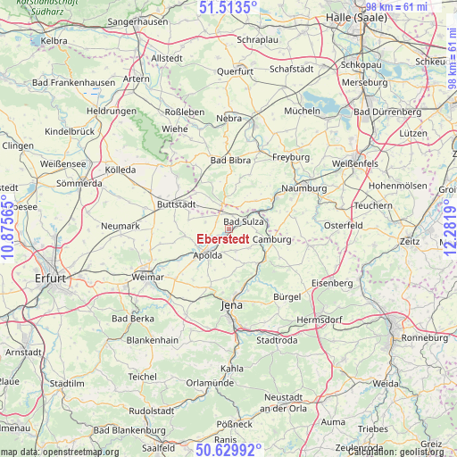
Eberstedt GPS coordinates[2]
51° 4' 25.752" North, 11° 34' 43.572" East
| Map corner | latitude | longitude |
|---|---|---|
| Upper-left | 51.5135°, | 10.87565° |
| Center: | 51.07382°, | 11.57877° |
| Lower-right: | 50.62992°, | 12.2819° |
| Map W x H: | 98.2×98.2 km | = 61×61mi |
| max Lat: | 55.01917° ⇑40.6% North |
| Eberstedt: | 51.07382° |
| min Lat: | ⇓59.4% South 47.40724° |
| min Long | Eberstedt | max Long |
| 5.92978° | 11.57877° | 14.98853° |
| W 75.5%⇐ | ⇒24.5% E |
Elevation
Elevation of Eberstedt is 137 m = 449 ft, and this is 112.1 m = 368 ft below average elevation for this country.
| Max E: |
1256 m = 4121 ft | 62.2% |
| Avg. | 249.1 m = 817 ft | |
| Eberstedt | 137 m = 449 ft | |
Min E: |
-5 m = -16 ft | 37.8% |
See also: Germany elevation on elevation.city.
Geographical zone
Eberstedt is located in North temperate zone (between Tropic of Cancer and the Arctic Circle). Distance of this North polar circle is 1722.3 km =1070.2 mi to North.| Distance of | km | miles | from Eberstedt |
|---|---|---|---|
| North Pole | 4328.2 | 2689.4 | to North |
| Arctic Circle | 1722.3 | 1070.2 | to North |
| Tropic Cancer | 3073 | 1909.5 | to South |
| Equator | 5678.9 | 3528.7 | to South |


Nearby cities:
15 places around Eberstedt: (largest is in red/bold)
• Apolda
6.9 km =4.3 mi,  219°
219°
• Bad Sulza
3.6 km =2.2 mi,  61°
61°
• Eckartsberga
5.7 km =3.5 mi,  347°
347°
• Großheringen
7.1 km =4.4 mi, 62°
• Hainichen
8.6 km =5.3 mi,  162°
162°
• Ködderitzsch
5.6 km =3.5 mi,  280°
280°
• Mattstedt
5.1 km =3.2 mi,  238°
238°
• Niederroßla
8 km =5 mi, 235°
• Nirmsdorf
7.9 km =4.9 mi,  286°
286°
• Rannstedt
2.3 km =1.4 mi,  297°
297°
• Schmiedehausen
6.2 km =3.9 mi,  97°
97°
• Taugwitz
6.9 km =4.3 mi,  34°
34°
• Wichmar
8.6 km =5.3 mi,  121°
121°
• Wickerstedt
3 km =1.9 mi, 238°
• Willerstedt
9 km =5.6 mi, 281°
Sources, notices
• [Note1] Compared only with cities in Germany existing in our database
• [Src1] Map data: © OpenStreetMap contributors (CC-BY-SA)
• [Src2] Other city data from geonames.org with taken over terms of usage.
• [Src3] Geographical zone / Annual Mean Temperature by Robert A. Rohde @ Wikipedia
