Wessin geodata
Wessin (Mecklenburg-Vorpommern) is a populated place; located in Germany in Europe/Berlin (GMT+2) time zone. With population of 532 people, there are 9181 cities with bigger population in this country. Compared to other cities in Germany, 86.5% of cities are located further ↓South; 77.6% of cities are located further ←West and 77% of cities have higher elevation than Wessin. Note1
Administrative division(s):
- Level 1: Mecklenburg-Vorpommern
- Level 3: Ludwigslust-Parchim
- Level 4: Crivitz


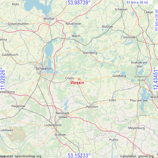
Wessin GPS coordinates[2]
53° 34' 18.912" North, 11° 43' 52.968" East
| Map corner | latitude | longitude |
|---|---|---|
| Upper-left | 53.98739°, | 11.02826° |
| Center: | 53.57192°, | 11.73138° |
| Lower-right: | 53.15233°, | 12.43451° |
| Map W x H: | 92.8×92.8 km | = 57.7×57.7mi |
| max Lat: | 55.01917° ⇑13.5% North |
| Wessin: | 53.57192° |
| min Lat: | ⇓86.5% South 47.40724° |
| min Long | Wessin | max Long |
| 5.92978° | 11.73138° | 14.98853° |
| W 77.6%⇐ | ⇒22.4% E |
Elevation
Elevation of Wessin is 56 m = 184 ft, and this is 193.1 m = 634 ft below average elevation for this country.
| Max E: |
1256 m = 4121 ft | 77% |
| Avg. | 249.1 m = 817 ft | |
| Wessin | 56 m = 184 ft | |
Min E: |
-5 m = -16 ft | 23% |
See also: Germany elevation on elevation.city.
Geographical zone
Wessin is located in North temperate zone (between Tropic of Cancer and the Arctic Circle). Distance of this North polar circle is 1444.5 km =897.6 mi to North.| Distance of | km | miles | from Wessin |
|---|---|---|---|
| North Pole | 4050.4 | 2516.8 | to North |
| Arctic Circle | 1444.5 | 897.6 | to North |
| Tropic Cancer | 3350.7 | 2082 | to South |
| Equator | 5956.6 | 3701.3 | to South |


Nearby cities:
15 places around Wessin: (largest is in red/bold)
• Banzkow
14.7 km =9.1 mi,  249°
249°
• Crivitz
5.2 km =3.2 mi,  271°
271°
• Demen
6.8 km =4.2 mi,  19°
19°
• Domsühl
9.8 km =6.1 mi,  164°
164°
• Friedrichsruhe
5.1 km =3.2 mi,  165°
165°
• Grebbin
10.8 km =6.7 mi,  125°
125°
• Hohen Pritz
12.3 km =7.6 mi,  58°
58°
• Matzlow-Garwitz
14 km =8.7 mi,  187°
187°
• Mestlin
13 km =8.1 mi,  85°
85°
• Pinnow
12.7 km =7.9 mi,  285°
285°
• Raduhn
10.5 km =6.5 mi,  197°
197°
• Sukow
11.6 km =7.2 mi, 254°
• Tramm
7.8 km =4.8 mi,  225°
225°
• Zapel
4.8 km =3 mi,  244°
244°
• Zölkow
6 km =3.7 mi,  99°
99°
Sources, notices
• [Note1] Compared only with cities in Germany existing in our database
• [Src1] Map data: © OpenStreetMap contributors (CC-BY-SA)
• [Src2] Other city data from geonames.org with taken over terms of usage.
• [Src3] Geographical zone / Annual Mean Temperature by Robert A. Rohde @ Wikipedia
