Friedrichsruhe geodata
Friedrichsruhe (Mecklenburg-Vorpommern) is a populated place; located in Germany in Europe/Berlin (GMT+2) time zone. With population of 759 people, there are 8052 cities with bigger population in this country. Compared to other cities in Germany, 85.8% of cities are located further ↓South; 78% of cities are located further ←West and 79.2% of cities have higher elevation than Friedrichsruhe. Note1
Administrative division(s):
- Level 1: Mecklenburg-Vorpommern
- Level 3: Ludwigslust-Parchim
- Level 4: Friedrichsruhe


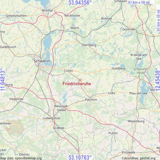
Friedrichsruhe GPS coordinates[2]
53° 31' 39.576" North, 11° 45' 4.5" East
| Map corner | latitude | longitude |
|---|---|---|
| Upper-left | 53.94356°, | 11.04813° |
| Center: | 53.52766°, | 11.75125° |
| Lower-right: | 53.10763°, | 12.45438° |
| Map W x H: | 92.9×92.9 km | = 57.7×57.7mi |
| max Lat: | 55.01917° ⇑14.2% North |
| Friedrichsruhe: | 53.52766° |
| min Lat: | ⇓85.8% South 47.40724° |
| min Long | Friedrichsruhe | max Long |
| 5.92978° | 11.75125° | 14.98853° |
| W 78%⇐ | ⇒22% E |
Elevation
Elevation of Friedrichsruhe is 49 m = 161 ft, and this is 200.1 m = 656 ft below average elevation for this country.
| Max E: |
1256 m = 4121 ft | 79.2% |
| Avg. | 249.1 m = 817 ft | |
| Friedrichsruhe | 49 m = 161 ft | |
Min E: |
-5 m = -16 ft | 20.8% |
See also: Germany elevation on elevation.city.
Geographical zone
Friedrichsruhe is located in North temperate zone (between Tropic of Cancer and the Arctic Circle). Distance of this North polar circle is 1449.5 km =900.7 mi to North.| Distance of | km | miles | from Friedrichsruhe |
|---|---|---|---|
| North Pole | 4055.3 | 2519.8 | to North |
| Arctic Circle | 1449.5 | 900.7 | to North |
| Tropic Cancer | 3345.8 | 2079 | to South |
| Equator | 5951.7 | 3698.2 | to South |


Nearby cities:
15 places around Friedrichsruhe: (largest is in red/bold)
• Crivitz
8.3 km =5.2 mi,  307°
307°
• Damm
9.8 km =6.1 mi,  178°
178°
• Demen
11.4 km =7.1 mi,  5°
5°
• Domsühl
4.7 km =2.9 mi,  163°
163°
• Granzin
13 km =8.1 mi,  102°
102°
• Grebbin
7.5 km =4.7 mi, 100°
• Matzlow-Garwitz
9.4 km =5.8 mi,  199°
199°
• Mestlin
13 km =8.1 mi,  63°
63°
• Parchim
13 km =8.1 mi,  150°
150°
• Raduhn
6.8 km =4.2 mi,  220°
220°
• Sukow
12.6 km =7.8 mi,  278°
278°
• Tramm
6.9 km =4.3 mi,  265°
265°
• Wessin
5.1 km =3.2 mi,  345°
345°
• Zapel
6.3 km =3.9 mi,  296°
296°
• Zölkow
6.1 km =3.8 mi,  49°
49°
Sources, notices
• [Note1] Compared only with cities in Germany existing in our database
• [Src1] Map data: © OpenStreetMap contributors (CC-BY-SA)
• [Src2] Other city data from geonames.org with taken over terms of usage.
• [Src3] Geographical zone / Annual Mean Temperature by Robert A. Rohde @ Wikipedia
