Werpeloh geodata
Werpeloh (Lower Saxony) is a seat of a fourth-order administrative division; located in Germany in Europe/Berlin (GMT+2) time zone. With population of 1,104 people, there are 6835 cities with bigger population in this country. Compared to other cities in Germany, 80.9% of cities are located further ↓South; 86.8% of cities are located further →East and 79.4% of cities have higher elevation than Werpeloh. Note1


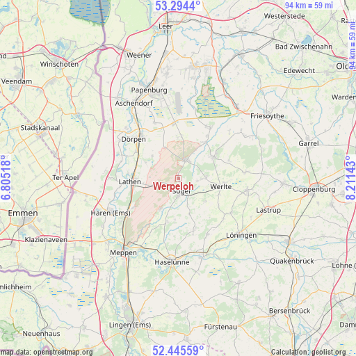
Werpeloh GPS coordinates[2]
52° 52' 19.452" North, 7° 30' 29.916" East
| Map corner | latitude | longitude |
|---|---|---|
| Upper-left | 53.2944°, | 6.80518° |
| Center: | 52.87207°, | 7.50831° |
| Lower-right: | 52.44559°, | 8.21143° |
| Map W x H: | 94.4×94.4 km | = 58.7×58.7mi |
| max Lat: | 55.01917° ⇑19.1% North |
| Werpeloh: | 52.87207° |
| min Lat: | ⇓80.9% South 47.40724° |
| min Long | Werpeloh | max Long |
| 5.92978° | 7.50831° | 14.98853° |
| W 13.2%⇐ | ⇒86.8% E |
Elevation
Elevation of Werpeloh is 48 m = 157 ft, and this is 201.1 m = 660 ft below average elevation for this country.
| Max E: |
1256 m = 4121 ft | 79.4% |
| Avg. | 249.1 m = 817 ft | |
| Werpeloh | 48 m = 157 ft | |
Min E: |
-5 m = -16 ft | 20.6% |
See also: Germany elevation on elevation.city.
Geographical zone
Werpeloh is located in North temperate zone (between Tropic of Cancer and the Arctic Circle). Distance of this North polar circle is 1522.4 km =946 mi to North.| Distance of | km | miles | from Werpeloh |
|---|---|---|---|
| North Pole | 4128.2 | 2565.1 | to North |
| Arctic Circle | 1522.4 | 946 | to North |
| Tropic Cancer | 3272.9 | 2033.7 | to South |
| Equator | 5878.8 | 3652.9 | to South |


Nearby cities:
15 places around Werpeloh: (largest is in red/bold)
• Breddenberg
11.5 km =7.1 mi,  36°
36°
• Börger
4.8 km =3 mi,  22°
22°
• Groß Berßen
11.2 km =7 mi,  184°
184°
• Hüven
9.9 km =6.2 mi, 176°
• Klein Berßen
12 km =7.5 mi,  195°
195°
• Kluse
13.3 km =8.3 mi,  302°
302°
• Lahn
9.5 km =5.9 mi,  130°
130°
• Lathen
12.9 km =8 mi,  267°
267°
• Lorup
10.8 km =6.7 mi,  57°
57°
• Neubörger
10.4 km =6.5 mi,  337°
337°
• Renkenberge
8.9 km =5.5 mi,  290°
290°
• Surwold
11.8 km =7.3 mi,  2°
2°
• Sögel
2.5 km =1.6 mi,  167°
167°
• Werlte
12 km =7.5 mi,  101°
101°
• Wippingen
8.9 km =5.5 mi,  310°
310°
Sources, notices
• [Note1] Compared only with cities in Germany existing in our database
• [Src1] Map data: © OpenStreetMap contributors (CC-BY-SA)
• [Src2] Other city data from geonames.org with taken over terms of usage.
• [Src3] Geographical zone / Annual Mean Temperature by Robert A. Rohde @ Wikipedia
