Weitersbach geodata
Weitersbach (Rheinland-Pfalz) is a seat of a fourth-order administrative division; located in Germany in Europe/Berlin (GMT+2) time zone. With population of 85 people, there are 10880 cities with bigger population in this country. Compared to other cities in Germany, 67.4% of cities are located further ↑North; 89.7% of cities are located further →East and 73.7% of cities have lower elevation than Weitersbach. Note1
Administrative division(s):
- Level 1: Rheinland-Pfalz
- Level 3: Landkreis Birkenfeld
- Level 4: Weitersbach


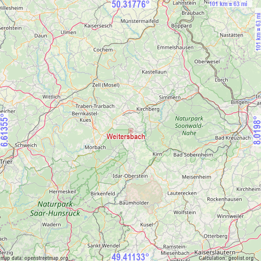
Weitersbach GPS coordinates[2]
49° 52' 0.012" North, 7° 19' 0.012" East
| Map corner | latitude | longitude |
|---|---|---|
| Upper-left | 50.31776°, | 6.61355° |
| Center: | 49.86667°, | 7.31667° |
| Lower-right: | 49.41133°, | 8.0198° |
| Map W x H: | 100.8×100.8 km | = 62.6×62.6mi |
| max Lat: | 55.01917° ⇑67.4% North |
| Weitersbach: | 49.86667° |
| min Lat: | ⇓32.6% South 47.40724° |
| min Long | Weitersbach | max Long |
| 5.92978° | 7.31667° | 14.98853° |
| W 10.3%⇐ | ⇒89.7% E |
Elevation
Elevation of Weitersbach is 388 m = 1273 ft, and this is 138.9 m = 456 ft above average elevation for this country.
| Max E: |
1256 m = 4121 ft | 26.3% |
| Weitersbach | 388 m 1273 ft | |
| Avg. | 249.1 m = 817 ft | |
Min E: |
-5 m = -16 ft | 73.7% |
See also: Germany elevation on elevation.city.
Geographical zone
Weitersbach is located in North temperate zone (between Tropic of Cancer and the Arctic Circle). Distance of this North polar circle is 1856.5 km =1153.6 mi to North.| Distance of | km | miles | from Weitersbach |
|---|---|---|---|
| North Pole | 4462.4 | 2772.8 | to North |
| Arctic Circle | 1856.5 | 1153.6 | to North |
| Tropic Cancer | 2938.7 | 1826 | to South |
| Equator | 5544.7 | 3445.3 | to South |


Nearby cities:
15 places around Weitersbach: (largest is in red/bold)
• Bollenbach
4.4 km =2.7 mi,  147°
147°
• Bundenbach
5.2 km =3.2 mi,  121°
121°
• Gösenroth
2.2 km =1.4 mi,  32°
32°
• Hausen
3.6 km =2.2 mi,  90°
90°
• Hottenbach
4.8 km =3 mi,  196°
196°
• Krummenau
4 km =2.5 mi,  297°
297°
• Laufersweiler
3.4 km =2.1 mi,  345°
345°
• Niederweiler
4.4 km =2.7 mi,  327°
327°
• Oberhosenbach
5.7 km =3.5 mi,  167°
167°
• Oberkirn
4 km =2.5 mi,  62°
62°
• Rhaunen
1.8 km =1.1 mi,  99°
99°
• Schwerbach
4.4 km =2.7 mi, 32°
• Sohrschied
4.4 km =2.7 mi, 32°
• Stipshausen
3 km =1.9 mi,  232°
232°
• Sulzbach
3.9 km =2.4 mi,  162°
162°
Sources, notices
• [Note1] Compared only with cities in Germany existing in our database
• [Src1] Map data: © OpenStreetMap contributors (CC-BY-SA)
• [Src2] Other city data from geonames.org with taken over terms of usage.
• [Src3] Geographical zone / Annual Mean Temperature by Robert A. Rohde @ Wikipedia
